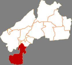
Tailai County (Chinese: 泰来县; pinyin: Tàilái Xiàn) is a county in the west of Heilongjiang province, People's Republic of China, bordering Inner Mongolia to the west and Jilin province to the south. It is the southernmost county-level division of the prefecture-level city of Qiqihar.
Tailai County
泰来县 T'ai-lai | |
|---|---|
 Tailai in Qiqihar | |
 Qiqihar in Heilongjiang | |
| Coordinates: 46°23′38″N 123°25′01″E / 46.394°N 123.417°E | |
| Country | People's Republic of China |
| Province | Heilongjiang |
| Prefecture-level city | Qiqihar |
| Area | |
• Total | 4,061 km2 (1,568 sq mi) |
| Population (2010) | |
• Total | 302,027 |
| • Density | 74/km2 (190/sq mi) |
| Time zone | UTC+8 (China Standard) |

Administrative divisions
editTailai County is divided into 7 towns, 1 ethnic town and 2 ethnic townships.[1]
- 7 towns
- Tailai (泰来镇), Pingyang (平洋镇), Tangchi (汤池镇), Tazicheng (塔子城镇), Daxing (大兴镇), Heping (和平镇), Keli (克利镇)
- 1 ethnic town
- Jiangqiao Mongol (江桥蒙古族镇)
- 2 ethnic townships
- Shengli Mongol (胜利蒙古族乡), Ningjiang Mongol (宁姜蒙古族乡)
Demographics
editThe population of the district was 322,562 in 1999.[2]
Climate
edit| Climate data for Tailai (1991–2020 normals, extremes 1981–2010) | |||||||||||||
|---|---|---|---|---|---|---|---|---|---|---|---|---|---|
| Month | Jan | Feb | Mar | Apr | May | Jun | Jul | Aug | Sep | Oct | Nov | Dec | Year |
| Record high °C (°F) | 5.8 (42.4) |
11.4 (52.5) |
24.7 (76.5) |
33.2 (91.8) |
38.0 (100.4) |
39.9 (103.8) |
38.4 (101.1) |
36.4 (97.5) |
34.5 (94.1) |
28.4 (83.1) |
18.4 (65.1) |
6.9 (44.4) |
39.9 (103.8) |
| Mean daily maximum °C (°F) | −10.3 (13.5) |
−4.4 (24.1) |
4.3 (39.7) |
14.6 (58.3) |
22.3 (72.1) |
27.3 (81.1) |
28.9 (84.0) |
27.3 (81.1) |
22.0 (71.6) |
12.7 (54.9) |
0.3 (32.5) |
−8.9 (16.0) |
11.3 (52.4) |
| Daily mean °C (°F) | −16.7 (1.9) |
−11.3 (11.7) |
−2.4 (27.7) |
8.0 (46.4) |
16.0 (60.8) |
21.6 (70.9) |
24.0 (75.2) |
22.0 (71.6) |
15.7 (60.3) |
6.4 (43.5) |
−5.4 (22.3) |
−14.7 (5.5) |
5.3 (41.5) |
| Mean daily minimum °C (°F) | −21.9 (−7.4) |
−17.4 (0.7) |
−8.7 (16.3) |
1.3 (34.3) |
9.6 (49.3) |
16.1 (61.0) |
19.3 (66.7) |
17.2 (63.0) |
9.9 (49.8) |
0.9 (33.6) |
−10.2 (13.6) |
−19.5 (−3.1) |
−0.3 (31.5) |
| Record low °C (°F) | −36.9 (−34.4) |
−35.4 (−31.7) |
−26.9 (−16.4) |
−9.9 (14.2) |
−2.4 (27.7) |
2.8 (37.0) |
8.9 (48.0) |
7.0 (44.6) |
−1.3 (29.7) |
−15.5 (4.1) |
−25.9 (−14.6) |
−33.4 (−28.1) |
−36.9 (−34.4) |
| Average precipitation mm (inches) | 1.8 (0.07) |
2.2 (0.09) |
5.3 (0.21) |
17.9 (0.70) |
31.9 (1.26) |
84.4 (3.32) |
114.7 (4.52) |
86.7 (3.41) |
43.0 (1.69) |
13.1 (0.52) |
3.8 (0.15) |
4.2 (0.17) |
409 (16.11) |
| Average precipitation days (≥ 0.1 mm) | 2.9 | 1.9 | 3.0 | 4.3 | 7.7 | 11.6 | 12.4 | 10.3 | 7.4 | 4.1 | 3.2 | 4.7 | 73.5 |
| Average snowy days | 4.6 | 3.3 | 4.1 | 1.8 | 0 | 0 | 0 | 0 | 0 | 1.1 | 4.5 | 6.1 | 25.5 |
| Average relative humidity (%) | 63 | 54 | 45 | 41 | 46 | 61 | 72 | 72 | 63 | 54 | 57 | 64 | 58 |
| Mean monthly sunshine hours | 189.6 | 207.9 | 253.2 | 250.8 | 270.0 | 264.0 | 255.4 | 255.2 | 247.8 | 219.0 | 178.0 | 165.3 | 2,756.2 |
| Percent possible sunshine | 67 | 71 | 68 | 61 | 58 | 56 | 54 | 59 | 67 | 66 | 64 | 62 | 63 |
| Source: China Meteorological Administration[3][4] | |||||||||||||
References
edit- ^ "国家统计局 2019" (in Chinese). National Bureau of Statistics of the People's Republic of China. Retrieved 2021-12-07.
- ^ (in English) National Population Statistics Materials by County and City - 1999 Period, in China County & City Population 1999, Harvard China Historical GIS
- ^ 中国气象数据网 – WeatherBk Data (in Simplified Chinese). China Meteorological Administration. Retrieved 5 July 2023.
- ^ 中国气象数据网 (in Simplified Chinese). China Meteorological Administration. Retrieved 5 July 2023.
External links
edit- (in Chinese) Government site - Google translation