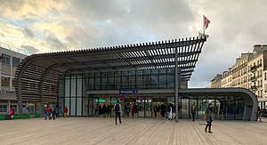
Vincennes station (French pronunciation: [vɛ̃sɛn] ) is a station on RER A the commune of Vincennes, Val-de-Marne.
Vincennes | ||||||||||||
|---|---|---|---|---|---|---|---|---|---|---|---|---|
 Vincennes station entrance | ||||||||||||
| General information | ||||||||||||
| Location | Vincennes France | |||||||||||
| Coordinates | 48°50′51″N 2°26′01″E / 48.84742°N 2.433524°E | |||||||||||
| Operated by | RATP Group | |||||||||||
| Platforms | 2 side platforms | |||||||||||
| Tracks | 2 | |||||||||||
| Connections | ||||||||||||
| Construction | ||||||||||||
| Structure type | Below-grade | |||||||||||
| Accessible | Yes, by request to staff[1] | |||||||||||
| Other information | ||||||||||||
| Station code | 87758110 | |||||||||||
| Fare zone | 2 | |||||||||||
| History | ||||||||||||
| Opened | 22 September 1859 | |||||||||||
| Passengers | ||||||||||||
| 2019 | 6,526,978 | |||||||||||
| Services | ||||||||||||
| ||||||||||||
Service
editVincennes is served by both eastern branches of the RER A line, the A2 towards Boissy-Saint-Léger, and the A4 towards Marne-la-Vallée–Chessy. It is the only station on the RER A in zone 2 and the last before the line splits into the A2 and A4.
Bus connections
editReferences
edit- ^ "Plan pour les voyageurs en fauteuil roulant" [Map for travelers in wheelchairs] (PDF). Île-de-France Mobilités. 2023. Retrieved 27 December 2023.
- ^ "Plan du réseau de bus à l'Est de Paris (Secteur n°10)" [Map of the RATP bus network to the east of Paris (Sector n° 10).] (PDF). Ratp.fr (Color map showing the names of bus stops and main streets.) (in French). RATP Group. May 2020. Retrieved 19 August 2020.
- ^ "Plan du réseau Noctilien (2017) - (Secteur : Paris & Sud-Est)" [Map of the night bus (Noctilien) network (2017) - (Sector: Paris and its south-eastern suburbs).] (PDF). Ratp.fr (Color map showing the names of the bus stops and the cities served.) (in French). RATP Group. April 2017. Retrieved 19 August 2020.
External links
editMedia related to Gare de Vincennes at Wikimedia Commons