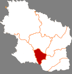
Xifeng District (Chinese: 西峰区; pinyin: Xīfēng Qū) is a district and the seat of the city of Qingyang in Gansu Province, China. It has an area of 996 km2 (385 sq mi) and a population of 376,800 in 2019.[2]
Xifeng
西峰区 | |
|---|---|
 Qingyang museum | |
 Xifeng in Qingyang | |
 Qingyang in Gansu | |
| Coordinates: 35°43′50″N 107°39′03″E / 35.7306°N 107.6507°E | |
| Country | China |
| Province | Gansu |
| Prefecture-level city | Qingyang |
| District seat | Nanjie Subdistrict |
| Area | |
| • Total | 996.35 km2 (384.69 sq mi) |
| Elevation | 1,421 m (4,662 ft) |
| Population (2020 census)[1] | |
| • Total | 513,856 |
| • Density | 520/km2 (1,300/sq mi) |
| Time zone | UTC+8 (China Standard) |
| Postal code | 745000 |
| Website | www |
Inhabited since prehistoric times, it first became an important town in the Ming dynasty, due to its location on the route from Chang'an (Xi'an) to Ningxia.[3]
In 1985, Xifeng was upgraded to a city in Qingyang Prefecture. In 2002, Qingyang Prefecture was upgraded to a prefecture-level city, and Xifeng City (county-level) became its district.[4]
Economy
editXifeng is known as the grain shed of eastern Gansu, but is also known for its fruit orchards.[3]
The Xifeng oilfield located in the district is one of the largest oilfields of the Ordos Basin. Although oil was presumed to be present under Xifeng since 1907, exploitation didn't start until the 1960s.[5]
Tourism
editXifeng is home to the Beishiku temple-grottoes, a system of 195 caves built in 509 AD.[6]
Geography
editThe district is located centrally on a loess plain named Dongzhiyuan (Chinese: 董志塬) flanked by gullies, at around 1421 m elevation. The plain is considered the world's largest of its kind and estimated to be around 200 m in thickness. Due to erosion, the plain has shrunk over 400 km2 (150 sq mi) on a total area of 2,200 km2 (850 sq mi) in the past 100 years.[7][8]
Administrative divisions
editXifeng District is divided into 3 Subdistricts, 5 towns, and 2 townships.[9]
- Subdistricts
- Beijie Subdistrict (北街办事处街道)
- Nanjie Subdistrict (南街办事处街道)
- Xijie Subdistrict (西街办事处街道)
- Towns
|
|
- Townships
- Shishe Township(什社乡)
- Xiansheng Township(显胜乡)
Transport
editReferences
edit- ^ "庆阳市第七次全国人口普查公报" (in Chinese). Qingyang Radio and Television. 2021-06-23.
- ^ Gansu Statistical Yearbook 2019
- ^ a b "西峰概况" [About Xifeng]. Xifeng Government.
- ^ 中国城市统计年鉴 (in Chinese). 中国统计信息资讯服務中心. 2003. ISBN 978-7-5037-4307-8.
- ^ Duan, Y.; Wang, C.Y.; Zheng, C.Y.; Wu, B.X.; Zheng, G.D. (2008-01-10). "Geochemical study of crude oils from the Xifeng oilfield of the Ordos basin, China". Journal of Asian Earth Sciences. 31 (4–6): 341–356. Bibcode:2008JAESc..31..341D. doi:10.1016/j.jseaes.2007.05.003. ISSN 1367-9120.
- ^ Gansu. Gansu People's Publishing House. 1984.
- ^ ""天下黄土第一塬"甘肃董志塬的"危"与"机"_省外媒体刊甘肃_中国甘肃网". gansu.gscn.com.cn. Retrieved 2021-04-11.
- ^ "隴东黄土高原溝壑區的水土保持試驗研究工作--《人民黄河》1956年11期". www.cnki.com.cn. Retrieved 2021-04-11.
- ^ "统计用区划代码 www.stats.gov.cn" (in Chinese). XZQH. Retrieved 2020-12-27.
