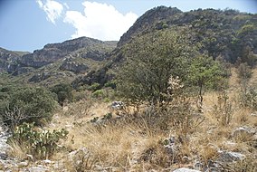
The Serranía de Zapalinamé, also known as the Sierra de Zapalinamé is a mountain range and protected area of northeastern Mexico. The city of Saltillo lies immediately north of the mountains.
| Serranía de Zapalinamé | |
|---|---|
| Sierra de Zapalinamé | |
 Camino de Cuatro in the Sierra de Zapalinamé | |
| Location | Coahuila, Mexico |
| Nearest city | Saltillo |
| Coordinates | 25°20′11″N 100°55′43″W / 25.33639°N 100.92861°W |
| Area | 253.74 km2 (97.97 sq mi) |
| Designation | ecological conservation |
| Designated | 1996 |
The range is a westward extension of the Sierra Madre Oriental. The highest peak in the range is El Penitiente at 3,140 meters elevation.[1]
Higher elevations are home to pine–oak forests. The lower slopes are dry shrublands. The Serranía is in the upper basin of the San Juan River, and its forests protect downstream water quality and reduce flood risk.
The Serranía de Zapalinamé was designated an ecological conservation area in 1996 by the state government of Coahuila. The protected area covers 253.74 km2.[2]
Wikimedia Commons has media related to Sierra de Zapalinamé.
References
edit- ^ Encina D., J. A., Encina D., F. J., & Mata R., E. (2011). "Ecología del Bosque de Ostrya virginiana (Betulaceae) de la Sierra de Zapalinamé, Coahuila, México". Journal of the Botanical Research Institute of Texas, 5(1), 305–310. http://www.jstor.org/stable/41972520
- ^ UNEP-WCMC (2021). Protected Area Profile for Serranía de Zapalinamé from the World Database of Protected Areas. Accessed 12 September 2021. [1]
