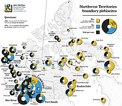
A plebiscite on the boundary between Northwest Territories and the new territory of Nunavut was held in the Northwest Territories on 4 May 1992.[1] The proposed border was approved by 54% of voters.[1] A second referendum later in the year gave the final approval to the creation of the new territory.[2]
Background
editA 1982 referendum had approved the division of the Northwest Territories and the creation of a new territory, later to become Nunavut. The federal government gave a conditional agreement to the plan seven months later.[3] In December 1991 the federal government reached an agreement with the Inuit on their land claims, with the "Parker line" (named for former Commissioner John Havelock Parker who worked on establishing the borders) set as the boundary between the existing territory and the new one.[1] The boundary roughly approximates the tree line in Canada.[4]
Results
edit| Choice | Votes | % |
|---|---|---|
| For | 8,347 | 54.39 |
| No | 7,000 | 45.61 |
| Invalid/blank votes | 124 | – |
| Total | 15,471 | 100 |
| Registered voters/turnout | 27,852 | 55.55 |
| Source: Direct Democracy | ||
References
edit- ^ a b c Northwest Territories (Canada), 4 May 1992: Border with Nunavut Direct Democracy (in German)
- ^ Nunavut (Canada), 5 November 1992: Creation of Nunavut Direct Democracy (in German)
- ^ Peter Jull. "Building Nunavut: A Story of Inuit SelfGovernment". The Northern Review No. 1 (Summer 1988). Yukon College. pp. 59–72. Archived from the original on August 5, 2016. Retrieved February 16, 2009.
- ^ Heidt, Daniel (2018). RECONSIDERING CONFEDERATION: Canada's Founding Debates, 1864–1999 (PDF). University of Calgary. pp. 263–264. ISBN 978-1-77385-016-0.
a new Northwest Territories and Nunavut ("our land" in Inuktitut)—were created when the federal govern-ment redrew the boundaries in Canada's North, splitting off the central and eastern Canadian Arctic north and east of the tree-line from the rest of the Northwest Territories.
