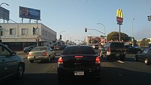
23rd Street is a major north-south trunk street in Richmond and San Pablo, California flanked by many Latino-oriented businesses.[1][2]

History
editThe street runs between San Pablo Avenue in the north and Interstate 580 in the south after which it becomes Marina Bay Parkway. It later meets up with 22nd Street at Grant Avenue. It is currently served by the AC Transit bus line 74 along its entirety and on portions by route 70, 76, 376, and 71 in addition to numerous 600 series school routes.[3]
The street is a major commercial sector for the city of Richmond and has mostly Latino themed and focused stores, particularly restaurants.[1] It hosts a Cinco de Mayo Festival every year, having a parade at Nevin Avenue in Richmond all the way into San Pablo.
On May 1, 2006 most of the storefronts on 23rd Street were closed in observance of the great American boycott known as "Day Without an Immigrant."[4] A protest was staged on 23rd Street with about 25,000 participants.[5]
The city of Richmond has many improvements planned after consulting with the community including adding sharrows for cyclists, wider sidewalks for pedestrians, parallel parking, and wider left turn lanes for vehicles.[6] There are also planned additions of street furniture, pedestrian lighting, trees and landscaping, decorative sidewalks and art, and wayfinding signage.[6]
Since 2006 the 23rd Street Merchants Association has sponsored a Cinco de Mayo festival along the street that now attracts thousands of patrons.[7] The event bans alcohol and is geared toward young people.[8]
Richmond High School is located along this street.
Major intersections
editThe entire street is in Contra Costa County.
| Location | mi[9] | km | Destinations | Notes | |
|---|---|---|---|---|---|
| Richmond | 0.0 | 0.0 | I-580 (John T. Knox Freeway) – El Cerrito, San Rafael | Southern terminus; I-580, exit 10A; roadway continues as Marina Bay Parkway. | |
| San Pablo | 2.8 | 4.5 | San Pablo Avenue - El Cerrito, Hercules | Northern terminus; roadway continues as Road 20. | |
| 1.000 mi = 1.609 km; 1.000 km = 0.621 mi | |||||
Notes
edit- ^ a b Point Molate Casino EIR, Volume I, 2009 Archived 2011-07-15 at the Wayback Machine accessed May 25, 2010
- ^ 23rd Street Corridor Visioning and Form-Based Code: Charette Summary Report Richmond, California Archived 2011-05-05 at the Wayback Machine. City of Richmond website. 26-08-2009. Retrieved 22-05-2011.
- ^ AC Transit system map Archived August 21, 2010, at the Wayback Machine, AC Transit website, access date 24 July 2010
- ^ US Counts Cost of Day Without Immigrants, The Guardian, by Dan Glaister and Ewen McAskill, May 1st, 2006. Retrieved Oct 15, 2018.
- ^ East Bay History: Richmond Archived 2019-10-21 at the Wayback Machine, access date Oct 15, 2018
- ^ a b 23rd Streetscape Project, City of Richmond website, access date December 28, 2008
- ^ Thousands Celebrate Cinco de Mayo in Richmond. Kornelia Trytko. Richmond Confidential. 2-05-11. Retrieved 07-05-2011.
- ^ The 23rd Street Cinco de Mayo Celebrations in Richmond and in San Pablo. Views. May 2011. Retrieved 07-05-2011.
- ^ "Route of 23rd Street" (Map). Google Maps. Retrieved March 23, 2014.