Al Tarfa (Arabic: الطرفة, romanized: Aţ Ţarfah) is a district in Qatar, located in the municipality of Ad Dawhah. Together with Jelaiah and Jeryan Nejaima, it makes up Zone 68 which has a total population of 5,521 as of 2015.[2]
Al Tarfa
الطرفة | |
|---|---|
District | |
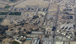
 Aerial view of Al Tarfa, looking west | |
| Coordinates: 25°22′32″N 51°29′19″E / 25.3755°N 51.4887°E | |
| Country | |
| Municipality | Ad-Dawhah |
| Zone | Zone 68 |
| District no. | 110 |
| Area | |
• Total | 6.4 km2 (2.5 sq mi) |
Jeryan Nejaima Street separates it from the district of the same name to west. To the east is Al Khor Coastal Road, which connects it with the municipality of Al Daayen.[3] Qatar University, the first institution of higher education established in the country, is based in the district.[4]
Etymology
editIn local dialect, the word "tarfa" refers to Tamarix aphylla, a short, salt-tolerant tree with scale-like leaves frequently planted for ornamental purposes or used as a shelterbelt. As the area is surrounded by a sabkha (salt flat), salinity levels are too high for most plants aside from Tamarix aphylla, which forms dense stands around the borders of the sabkha.[3]
Geography
editAl Tarfa borders the following districts:[3]
- Wadi Al Banat in Al Daayen Municipality to the northwest, separated by Al Tarfa Street.
- Al Egla in Al Daayen Municipality to the northeast, separated by Al Khor Coastal Road.
- West Bay Lagoon to the east, separated by University Street.
- Jelaiah to the south, separated by Jelaiah Street.
- Jeryan Nejaima to the west, separated by Jeryan Nejaima Street.
Aside from the large sabkha enclosing the district, two other geographic features of interest are Wadi Jafn Al Dabb and Rawdat Jafn Al Dabb.[3]
Landmarks
edit- College of the North Atlantic - Qatar on Jeryan Nejaima Street.[3]
- Qatar University Health Center on Jeryan Nejaima Street.[3]
- Qatar University Stadium on Al Jamiaa Street.[3]
- Al Tarfa Roundabout (also known as Golf Course Roundabout).[5]
References
edit- ^ "District Area Map". Ministry of Development Planning and Statistics. Retrieved 1 March 2019.
- ^ "2015 population census" (PDF). Ministry of Development Planning and Statistics. Archived from the original (PDF) on 14 February 2017. Retrieved 29 December 2018.
- ^ a b c d e f g "District map". The Centre for Geographic Information Systems of Qatar. Archived from the original on 24 November 2020. Retrieved 29 December 2018.
- ^ "Qatar University". Times Higher Education. Retrieved 30 December 2018.
- ^ "Partial Closure on University Street and Al Tarfa Roundabout". Qatar Tribune. 12 December 2017. Retrieved 7 February 2019.

