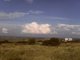
Albínovská hora,[1] sometimes also Albínovská hôrka (translated to English as Albinov Hill or Albinov Mountain,[2] in local dialect Baňa—Mine from Hungarian Bánya[3]) is a hill located on the west part of Sub-Slanec Hills, division of Eastern Slovak Hills, in eastern Slovakia. The hill is high 177 metres (581 ft) and it is located in the administrative area of Sečovce, 1.7 kilometres (1 mi) north of the residential area.[4][5]
| Albínovská hora | |
|---|---|
 View from the hill to the east | |
| Highest point | |
| Elevation | 177 metres (581 ft) |
| Coordinates | 48°42′55″N 21°38′56″E / 48.71528°N 21.64889°E |
| Geography | |
| Location | Sečovce, Slovakia |
| Parent range | Eastern Slovak Hills |
| Climbing | |
| Easiest route | YDS Class 1 (path) |
Remains of Tertiary volcanic activity in the area (see Slanské Hills) is andesite and characteristic tuff, covered under layers by Neogene sedimentary rocks – gravel, sand, kaolin etc.[6]
Footnotes
edit- ^ Standardized name, see Hajčíková, Marta; Seitzová, Silvia; Majtán, Milan (1991), Geografické názvy okresu Trebišov [Geographical Names of TrebiSov District], Bratislava: Slovenský úrad geodézie a kartografie, p. 51, OCLC 320719712
- ^ About Sečovce, The Town of Sečovce, Retrieved 13 February 2015
- ^ The Second Military Survey (1806–1869), Mapire – Historical Maps of the Habsburg Empire, Retrieved 13 February 2015
- ^ Turistický atlas – Slovenská republiky 1:100 000, Harmanec: Vojenský kartografický ústav, 2004, ISBN 8080424020, p. 67
- ^ Slanské vrchy – Dargov 1:50 000, Harmanec: Vojenský kartografický ústav, 1996, ISBN 8080420181, 2 s. (map list 58 x 102 cm)
- ^ Magyar, Július (2009), Prírodné podmienky, in Ordoš, Ján, edi. Sečovce, 2nd edition, Prešov: L.I.M., pp. 7–24, ISBN 8096804383, p.13
