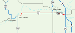
Highway 7 is an east–west highway in the Calgary Region of Alberta, Canada. It spans approximately 26 km (16 mi) from Highway 22 (Cowboy Trail) to Highway 2.[1][2]
 | ||||
| Route information | ||||
| Maintained by the Ministry of Transportation and Economic Corridors | ||||
| Length | 26.2 km[1] (16.3 mi) | |||
| Major junctions | ||||
| West end | ||||
| East end | ||||
| Location | ||||
| Country | Canada | |||
| Province | Alberta | |||
| Specialized and rural municipalities | Foothills County | |||
| Towns | Diamond Valley, Okotoks | |||
| Highway system | ||||
|
| ||||
| ||||
Highway 7 begins in the Town of Diamond Valley, which was created on January 1, 2023 with the merger of the towns of Black Diamond and Turner Valley.[3] The highway continues east, passing along the southern boundary of the Town of Okotoks. East of Okotoks, the highway ends at Highway 2 north of the Hamlet of Aldersyde, and is succeeded by Highway 547.[1][2][4]
Highway 7 originally continued south from Black Diamond to Longview, but the section was renumbered replaced by Highway 22 in the early 1970s.[5][6]
Major intersections
editThe following is a list of major intersections along Alberta Highway 7 from west to east.[1][2] The entire route is in Foothills County.
| Location | km[4] | mi | Destinations | Notes | |
|---|---|---|---|---|---|
| Diamond Valley | 0.0 | 0.0 | Highway 22 (Government Road / Centre Avenue) – Longview, Bragg Creek, Calgary | Continues as Hwy 22 north | |
| Okotoks | 19.3 | 12.0 | Highway 2A north (Southridge Drive) / Highway 783 south – Calgary | West end of Hwy 2A concurrency | |
| 20.9 | 13.0 | 32 Street E | |||
| Aldersyde | 25.2 | 15.7 | Highway 2A south – High River | East end of Hwy 2A concurrency | |
| 26.2 | 16.3 | Highway 2 – Calgary, Fort Macleod, Lethbridge Highway 547 east – Mossleigh | Interchange; Hwy 2 exit 209; continues as Hwy 547 east | ||
1.000 mi = 1.609 km; 1.000 km = 0.621 mi
| |||||
References
edit- ^ a b c d "2016 Provincial Highway 1-216 Progress Chart" (PDF). Alberta Transportation. March 2016. Archived (PDF) from the original on November 12, 2016. Retrieved November 12, 2016.
- ^ a b c Alberta Official Road Map (Map) (2010 ed.). Alberta Tourism, Parks and Recreation. § M-5.
- ^ Hunt, Stephen (January 1, 2023). "2 Alberta towns merge to create Diamond Valley". CTV News Calgary. CTV News. Retrieved January 1, 2023.
- ^ a b "Highway 7 in southern Alberta" (Map). Google Maps. Retrieved November 20, 2017.
- ^ Department of Highways (1960). Alberta Official Road Map (PDF) (Map). The Province of Alberta. Archived from the original (PDF) on October 19, 2021.
- ^ Travel Alberta (1972). Alberta Official Road Map (Map). The Province of Alberta.
