13°12′S 49°3′E / 13.200°S 49.050°E
Ambilobe | |
|---|---|
 Ambilobe | |
| Coordinates: 13°12′S 49°3′E / 13.200°S 49.050°E | |
| Country | |
| Region | Diana |
| District | Ambilobe |
| Government | |
| • Mayor | Zella Carbonel |
| Area | |
| • Land | 131 km2 (51 sq mi) |
| Elevation | 47 m (154 ft) |
| Population (2018)[3] | |
| • Total | 62,346 |
| Time zone | UTC3 (EAT) |
| Postal code | 204 |
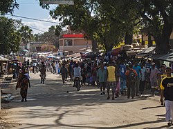
Ambilobe [amˌbilʷˈbe] is an urban municipality in Madagascar. It belongs to the district of Ambilobe, which is a part of Diana Region. The town is the capital of Ambilobe district, and according to 2018 census the population was approximately 62,346.[4][3]

Geography
editIt is situated at the Mahavavy River and the Route Nationale 6 at its junction with the Route Nationale 5a to the Sava region.
In addition to primary schooling the town offers secondary education at both junior and senior levels. The town provides access to hospital services to its citizens. Farming and raising livestock provides employment for 40% and 35% of the working population. The most important crop is sugarcane, while other important products are cotton, rice and tomato. Industry and services provide employment for 13% and 2% of the population, respectively. Additionally fishing employs 10% of the population.[3]
Airport
editThe town is served by an airport known as the Ambilobe Airport.[5] There are no regular flights to Ambilobe.
Economy
editIn Ambilobe is found the largest sugar mill of Madagascar (Sucoma) that produced 61.714 tons in 2018/2019.[6]
In the village of Sangaloka that belongs to the municipality of Ambilobe, the main activity is the manufacture of ceramics.[7]
Notable Personalities
editAlbert Zafy, Madagascar's president from 1993 until 1996, was born in Ambilobe.
Climate
editClassified as a tropical monsoon climate, occasionally also known as a tropical wet climate or tropical monsoon and trade-wind littoral climate. The Köppen Climate Classification subtype for this climate is "Am" (Tropical Monsoon Climate).[8]
References
edit- ^ Journal Madagascar
- ^ Estimated based on DEM data from Shuttle Radar Topography Mission
- ^ a b c "ILO census data". Cornell University. 2002. Retrieved 2008-02-13.
- ^ "Madagascar: Regions, Cities & Urban Communes - Population Statistics, Maps, Charts, Weather and Web Information". www.citypopulation.de. Retrieved 2024-01-17.
- ^ Airport information for Ambilobe Airport (FMNE)[usurped]. DAFIF. October 2006.
- ^ CMCS -Centre Malgache de la Canne et du Sucre/
- ^ La Tribune de Diego: Ambilobe - Potteries from Sengaloka
- ^ "Climate Summary for Ambilobe". Weatherbase.com. Retrieved 2013-12-17.
