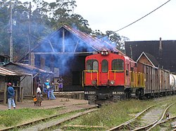
Andasibe (also Andasibe Gara) is a rural municipality in Madagascar. It belongs to the district of Moramanga, which is a part of Alaotra-Mangoro Region. The population of the commune was estimated to be approximately 13,493 in 2006.
Andasibe | |
|---|---|
 Andasibe station | |
| Coordinates: 18°56′S 48°25′E / 18.933°S 48.417°E | |
| Country | |
| Region | Alaotra-Mangoro |
| District | Moramanga |
| Area | |
| • Total | 363 km2 (140 sq mi) |
| Elevation | 810 - 1,200 m (−3,130 ft) |
| Population (2006)[1] | |
| • Total | 13,493 |
| Time zone | UTC3 (EAT) |
Geography
editThe town lies along the RN 2 at 140 km from Antananarivo, 26 km from Moramanga and 200 km from Toamasina.[1] It is a railway station on the Antananarivo – East Coast line.
Economy
editThe nearby national parks offer many job creations in the town. It is also a site of industrial-scale mining. Sixty-percent of the commune's population is farmers. The most important crop is rice, while other important products are corn, bananas and manioc. Industry and services provide both employment for 20% of the population.
Primary and junior-level secondary education are available in town.
Religion
edit- FJKM - Fiangonan'i Jesoa Kristy eto Madagasikara (Church of Jesus Christ in Madagascar)[2]
- Roman Catholic Church
Rivers
editThe town is crossed by the Sahatandra and Vohitra rivers.
See also
editReferences and notes
edit- ^ a b c Andrianarimanana, Rivo Haingotiana. "L'écotourisme : une stratégie pour un développement durable à l'exemple du Parc National D'Andasibe Mantadia (PNAM)" [Ecotourism: a strategy for sustainable development following the example of Andasibe Mantadia National Park (PNAM)] (PDF). biblio.univ-antananarivo.mg (in French). Archived (PDF) from the original on 2021-05-05.
- ^ A, Nandrianina (2019-11-19). "www.lagazette-dgi.com". La Gazette. Archived from the original on 2021-05-05. Retrieved 2021-05-05.
18°56′S 48°25′E / 18.933°S 48.417°E
