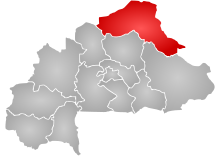
Aribinda Airport (IATA: XAR, ICAO: DFOY) is an airport serving the village of Aribinda in the Soum Province, part of the Sahel Region of Burkina Faso.
Aribinda Airport | |||||||||||
|---|---|---|---|---|---|---|---|---|---|---|---|
| Summary | |||||||||||
| Serves | Aribinda, Soum Province, Sahel Region, Burkina Faso | ||||||||||
| Location | |||||||||||
| Elevation AMSL | 342 m / 1,122 ft | ||||||||||
| Coordinates | 14°13′00″N 00°53′00″W / 14.21667°N 0.88333°W | ||||||||||
| Maps | |||||||||||
 Sahel Region in Burkina Faso | |||||||||||
 | |||||||||||
| Runways | |||||||||||
| |||||||||||
Source: [1] | |||||||||||
The airport is likely long abandoned. However, a listing for the airfield still appears in the official ASECNA Aeronautical Information Publication for Burkina Faso, quoting coordinates N14 13.0 W000 53.0.[1] Furthermore, the airport still has a valid 3-letter code allocated by IATA,[2] though a search of the ICAO database reveals no 4-letter ICAO location indicator code.[3]
References
edit- ^ a b "AIS ASECNA - Ad.2 : Aérodromes". www.ais-asecna.org. Archived from the original on 2018-08-20. Retrieved 2018-08-20.
- ^ IATA. "IATA - Codes - Airline and Airport Codes Search". www.iata.org. Retrieved 2018-08-20.
- ^ "API Data Service". www.icao.int. Retrieved 2018-08-20.
External links
edit- ASECNA AIP for Burkina Faso
- IATA location code search
- ICAO location indicator search
- OurAirports
- GCMap
- FallingRain
- Maplandia
- WorldAirportCodes
