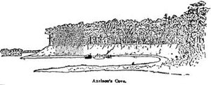
Axelson Point is a small cape along the shore of the East Bay in Navarre, Florida.[1][2] The point is sometimes mistakenly called Diana's Point by local residents, though the origin of this is unclear.[3]
Axelson Point
Diana's Point | |
|---|---|
 A sketch of Axelson Point made in 1915 | |
 | |
| Coordinates: 30°27′08″N 86°55′43″W / 30.452323°N 86.928735°W | |
| Range | Gulf Coastal Plain |
| Part of | Fairpoint Peninsula |
| Offshore water bodies | East Lagoon (East Bay) |
| Operator | Robledal Estates neighborhood (and various homeowners) |
| Elevation | 2 m (7 ft) |
| Etymology | Axelson Family |
The point is named after the Axelson Family, one of the first families permanently residing in Navarre. The point only extends less than a hundred meters into the bay. The Axelsons operated a shipyard on the point, using lumber from Miller Point across the bay.[4]
The point is historically significant, not only due to it being the home of the previously mentioned Axelson family, but also due to it being one of the first landing spots for exploration in the area.[2][3] Some of the Pensacola homes of the original Axelson family still stand today; however, none of the homes on Axelson Point are from the original family.[2]
Axelson Point, together with Miller Point, make up the mouth of East Lagoon, the river-like eastern reaches of East Bay.[5]
References
edit- ^ "GNIS Detail - Axelson Point". geonames.usgs.gov. Retrieved 2019-03-18.
- ^ a b c "Navarre's earliest recorded heritage began with Spanish explorers in 1693". Navarre Press. 2016-07-06. Retrieved 2019-03-18.
- ^ a b "Robledal History". robledal.org. Retrieved 2019-03-18.
- ^ Clark (2017-04-04). "Small Boat Restoration: Axelson Shipyard East Bay Navarre Florida Willow Log 04 Apr 17". Small Boat Restoration. Retrieved 2022-01-13.
- ^ "Map of Pensacola Bay". Library of Congress via Explore Florida. 1781. Archived from the original on 2002-03-08.