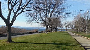
Battery Park is a public park overlooking Lake Champlain at the western end of downtown Burlington, Vermont. The park includes a bandshell, a playground, and various monuments, including a bronze statue of Civil War veteran General William W. Wells, and a red oak sculpture of Chief Gray Lock, a veteran of Gray Lock's War.[1] Locally, it is popular for its wide, sweeping views of Lake Champlain.
| Battery Park | |
|---|---|
 | |
 | |
| Location | Located at the top of Battery Street in downtown Burlington, Vermont |
| Area | 14 acres (6 ha) |
| Created | 1870 |
| Etymology | Built as a military camp during the War of 1812 |
| Operated by | City of Burlington Parks, Recreation & Waterfront |
| Website | http://enjoyburlington.com/venue/battery-park/ |
History
editThe park was named for the artillery stationed there by American forces during the War of 1812.[1] On August 13, 1813, American gunners, aided by the USS President, successfully defended their position against an attack by a British squadron led by Lt Colonel John Murray.[2]
The park land was deeded to the City of Burlington in 1870, and the Battery Park Extension was added to the southern end in 1972.[1]
Trivia
edit- Because of its unobstructed view high above Burlingon's harbor, Battery Park is a very popular spot for observers of the Independence Day fireworks launched from a barge in the bay.
- According to noted author Rudyard Kipling (The Jungle Book), Battery Park has one of the two finest sunset views in the world, with the other location being Kenya’s Ngong Hills.[3]
References
edit- ^ a b c "Battery Park | Burlington Parks, Recreation & Waterfront". Burlington Parks, Recreation & Waterfront. Retrieved 2018-03-29.
- ^ "Burlington and the War of 1812 | City of Burlington, Vermont". www.burlingtonvt.gov. Retrieved 2018-03-29.
- ^ "Lyndon B. Johnson: Remarks at Battery Park, Burlington, Vermont - August 20, 1966". www.presidency.ucsb.edu. Retrieved 2016-05-10.
Links
edit- Vermont Department of Parks and Recreation
- President Lyndon B. Johnson's Remarks at Battery Park
- Battle at Burlington (1813)
44°28′52″N 73°13′12″W / 44.4810733°N 73.2199423°W