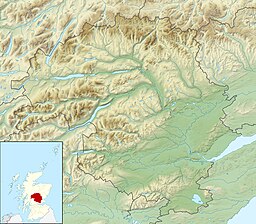
Black Loch is a small lowland freshwater loch that is located directly to the east of Fingask Loch in the valley of the Lunan Burn and is 1 mile south of Blairgowrie, in Perth and Kinross.[1][2]
| Black Loch | |
|---|---|
 Black Loch, Carsie, near Blairgowrie | |
| Location | NO175427 |
| Coordinates | 56°34′09″N 3°20′36″W / 56.569100°N 3.343300°W |
| Type | freshwater loch |
| Max. length | 0.402 km (0.250 mi)[1] |
| Max. width | 0.1609 km (0.1000 mi)[1] |
| Surface area | 2.6 ha (6.4 acres)[2] |
| Average depth | 4.75 ft (1.45 m)[1] |
| Max. depth | 7 ft (2.1 m)[1] |
| Water volume | 1,611,000 cu ft (45,600 m3)[1] |
| Shore length1 | 0.8 km (0.50 mi) [2] |
| Surface elevation | 51 m (167 ft)[2] |
| Max. temperature | 60.1 °F (15.6 °C) |
| Min. temperature | 57.4 °F (14.1 °C) |
| Islands | 0 |
| 1 Shore length is not a well-defined measure. | |
The loch is also a designated Site of Special Scientific Interest (SSSI), as well as forming part of a Special Area of Conservation.[3]
Geography
editBlack Loch lies to the east of two other small lochs. Directly to the east is White Loch and further east still is Fingask Loch and all within a distance of half a mile. Part of the eastern end of White Loch and all of Black Loch are within the bounds of Blairgowrie Golf Club.[4]
See also
editReferences
edit- ^ a b c d e f John, Murray; Lawrence, Pullar. Bathymetrical Survey of the Fresh-Water Lochs of Scotland, 1897-1909 Lochs of the Tay Basin Volume II - Black Loch. National Library of Scotland. p. 109. Retrieved 18 June 2019. This article incorporates text from this source, which is in the public domain.
- ^ a b c d "Black Loch". British Lakes. Retrieved 18 June 2019.
- ^ Dunkeld - Blairgowrie Lochs, Joint Nature Conservation Committee
- ^ Gittings, Bruce; Munro, David. "Black Loch, Perth and Kinross". The Gazetteer for Scotland. School of GeoSciences, University of Edinburgh and The Royal Scottish Geographical Society. Retrieved 18 June 2019.
