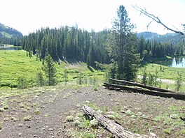
Bonny Lakes are two small, shallow, mountain ponds located in the Eagle Cap Wilderness of Northeastern Oregon, United States. They are positioned in a large meadow on Aneroid Mountain known as Bonny Lakes basin,[3] which is about two miles east of Dollar Lake.[4] Together they are listed as the 13th highest lake in the Eagle Cap Wilderness at 7,840 ft (2,390 m).[2]
| Bonny Lakes | |
|---|---|
 Both west and east lakes | |
 The more western of the two lakes | |
| Location | Eagle Cap Wilderness, Wallowa County, Oregon, US |
| Coordinates | 45°11′01″N 117°09′40″W / 45.1834889°N 117.1610013°W[1] |
| Type | Pond |
| Primary inflows | Big Sheep Creek |
| Primary outflows | Big Sheep Creek |
| Basin countries | United States |
| Max. length | West Lake: 195 yd (178 m) East Lake: 189 yd (173 m) |
| Max. width | West Lake: 189 yd (173 m) East Lake: 80 yd (73 m) |
| Average depth | West Lake: 6 ft (1.8 m) East Lake: 4 ft (1.2 m) |
| Surface elevation | 7,840 ft (2,390 m)[2] |
Trail
editBonny Lakes can be accessed by either the Wallowa Lake Trailhead (10 miles of travel) or the Tenderfoot Trailhead (3.5 miles of travel).[5] The lakes lie on Trail 1802.
See also
editReferences
edit- ^ "Bonny Lakes". Geographic Names Information System. United States Geological Survey, United States Department of the Interior. Retrieved 2008-11-21.
- ^ a b "Elevations of Points Near Eagle Cap Wilderness". Wallowa-Whitman National Forest. U.S. Forest Service. Archived from the original on 2008-09-17. Retrieved 2008-11-24.
- ^ "Petes Point". Peakware.com. Archived from the original on 2016-03-04. Retrieved 2009-03-03.
- ^ Barstad, Frank (2002). Hiking Oregon's Eagle Cap Wilderness. Morris Book Publishing.
- ^ "Bonny Lake Panorama". Archived from the original on 2008-07-05. Retrieved 2009-03-03.

