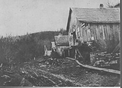
Boonford is a ghost town in Yancey County, North Carolina, and Mitchell County, North Carolina in the United States, located near present-day North Carolina Highway 80.
Boonford, North Carolina | |
|---|---|
 The Clinchfield Railroad station in Boonford | |
| Coordinates: 35°55′49.43″N 82°10′8.44″W / 35.9303972°N 82.1690111°W | |
| Country | United States |
| State | North Carolina |
| County | Yancey, Mitchell |
| Established | 1902 |
| Named for | Daniel Boone |
| Elevation | 2,421[1] ft (996 m) |
| Population | |
• Total | 0 |
| Time zone | UTC-5 (Eastern (EST)) |
| • Summer (DST) | UTC-4 (EDT) |
| ZIP code | 28705, 28714 |
| Area code | 828 |
| GNIS feature ID | 1019262 |
History
editBoonford was named for Daniel Boone, as it was said he forded the North Toe River at the site.[2] The town's development was spurred on by the arrival of the Clinchfield Railroad in 1902, on its line to Johnson City, Tennessee. Nearly every structure in the town no longer exists.[3]
Boonford's U.S. Post Office opened on November 17, 1902, in Yancey County.[4] It was moved to Mitchell County on December 28, 1914, and closed on May 31, 1951.[5]
The town was home to a number of feldspar and mica mines.[6]
References
edit- ^ US Department of the Interior, USGS. "Geographic Names Information System". edits.nationalmap.gov. Retrieved 2023-10-21.
- ^ "North Carolina Gazetteer browse | NCpedia". ncpedia.org. Retrieved 2023-10-21.
- ^ Shook, Mitzi (1981). "Historic and Architectural Resources of Yancey County, North Carolina". North Carolina Department of Natural and Cultural Resources. Retrieved 21 October 2023.
- ^ "Yancey County Post Offices 1833 to 1971 - Alphabetical Order". www.carolana.com. Retrieved 2023-10-21.
- ^ "Mitchell County Post Offices 1861 to 1971 - Alphabetical Order". www.carolana.com. Retrieved 2023-10-21.
- ^ Drane, Brent; Stuckey, Jasper (1925). The Mineral Industry in North Carolina, 1918 to 1923 (Economic Paper No. 55 ed.). Raleigh, North Carolina: North Carolina Geological and Economic Society. pp. 39, 45.
