This article needs additional citations for verification. (February 2013) |
Camden Park is just outside the metropolitan area of Sydney, Australia. It was named after John Macarthur's estate Camden Park. While most of the suburb is farmland in Wollondilly Shire, the northern part of Camden Park has recently undergone suburban development as an extension of the suburb of Camden South. Camden South is in the Camden Council area and is part of Greater Sydney. The new development is named Bridgewater Estate and features a comprehensive Development Control Plan to guide the style outcomes of the locality.
| Camden Park Sydney, New South Wales | |||||||||||||||
|---|---|---|---|---|---|---|---|---|---|---|---|---|---|---|---|
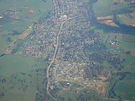
 New development at Camden Park (bottom of picture) just south of Camden South. | |||||||||||||||
 | |||||||||||||||
| Coordinates | 34°05′25″S 150°43′04″E / 34.09028°S 150.71778°E | ||||||||||||||
| Population | 2,238 (2016 census)[1] | ||||||||||||||
| Postcode(s) | 2570[2] | ||||||||||||||
| Elevation | 73 m (240 ft) | ||||||||||||||
| Location |
| ||||||||||||||
| LGA(s) | Wollondilly Shire | ||||||||||||||
| State electorate(s) | Camden | ||||||||||||||
| Federal division(s) | Hume | ||||||||||||||
| |||||||||||||||
Population
editIn the 2016 Census, there were 2,238 people in Camden Park. 86.3% of people were born in Australia and 92.9% of people spoke only English at home. The most common responses for religion were Catholic 38.9%, Anglican 27.6% and No Religion 16.9%.[1]
Heritage listings
editCamden Park has a number of heritage-listed sites, including:
- Elizabeth Macarthur Avenue: Camden Park Estate[3]
References
edit- ^ a b Australian Bureau of Statistics (27 June 2017). "Camden Park (State Suburb)". 2016 Census QuickStats. Retrieved 13 July 2017.
- ^ "Postcodes Australia | Postcode Search & Finder".
- ^ "Camden Park". New South Wales State Heritage Register. Department of Planning & Environment. H00341. Retrieved 18 May 2018. Text is licensed by State of New South Wales (Department of Planning and Environment) under CC BY 4.0 licence.
