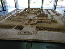
Cancho Roano (sometimes Cancho Ruano) is an archaeological site located in the municipality of Zalamea de la Serena, in the province of Badajoz, Spain. It is located three miles from Zalamea de la Serena in the direction of Quintana de la Serena Quintana, in a small valley along the stream Cagancha.

History
editCancho Roano is the best preserved Tartessian site. It dates back to at least the sixth century BCE, although the building was expanded and modified in later centuries. Based on the dating of objects found on the site, Cancho Roano is estimated to date from 550 BCE. The site was destroyed in a fire no later than 370 BCE. The building appears to have been ritually burned and sealed in rammed earth in a manner similar to Etruscan. The main body of the building is square and oriented toward the east. The building is surrounded by a deep moat, which was permanently filled with water. Although Cancho Roano's exact function is unknown, the religious character of the site is undeniable due to the presence of altars; however, the site may be a palace-shrine, judging from its defensive system.
Discovery and excavations
editExcavations of the site, directed by John Maluquer de Motes, began in 1978 and continued through 2001. It was declared a National Monument in 1986. The site, along with an interpretation center, is open to the public.
Interpretations
editThe evident sacred character of the building and the presence of multiple cells have attracted the idea of a temple dedicated to sacred prostitution, possibly dedicated to the Phoenician deity Astarte.[1][2] The hypothesis is supported by the presence of looms in two of the chambers, evoking the weavers of the goddess Asherah that worked as prostitutes in the ancient Temple of Jerusalem.[3] Similar rites would have been identified on the iconography of other Phoenician sites in Hispania, like Gadir, Castulo and La Quéjola (Albacete).[4] Another possibility would be a palace meant to accommodate a harem, whose members would likely act in sacred rites on the temple.[5][3][4]
Richard Freund theorizes that Cancho Roano was a "memorial city" designed to serve as a ceremonial representation of the lost city of Tartessos, which, in Freund's theory, was also Atlantis. Freund argued that a stele found at Cancho Roano displayed an image with concentric circles that matches Plato's description of Atlantis.[6] Nonetheless, Freund's theories have been widely dismissed in academic circles, and the symbol is not much more than a typical warrior shield engraved in the Southwestern Stelae from the Iberian Peninsula, of which there are many examples.[7]
See also
editReferences
edit- ^ José María Blázquez Martínez, El santuario de Cancho Roano (Badajoz) y la prostitución sagrada, Aula orientalis: revista de estudios del Próximo Oriente Antiguo, ISSN 0212-5730, Vol. 17, Nº 18, 1999, pg. 367-379
- ^ Mariano Torres Ortiz, Tartessos, 2002, Real Academia de la Historia, ISBN 9788495983039
- ^ a b Fernando López Pardo, Humanos en la mesa de los dioses: la escatológica fenicia y los frisos de Pozo Moro. A. González Prats (ed.), El mundo funerario. Actas del III Seminario Internacional sobre Temas Fenicios. Guardamar del Segura, May 3–5, 2002. Homenaje al Prof. D. Manuel Pellicer Catalán, Alicante, 2004, 495-537
- ^ a b Teresa Moneo, Religio iberica: santuarios, ritos y divinidades (siglos VII-I A.C.), 2003, Real Academia de la Historia, ISBN 9788495983213
- ^ José María Blázquez Martínez, El santuario de Cancho Roano[permanent dead link]. F. Villar – M. P. Fernández Álvarez (eds.), Religión, lengua y cultura prerromanas de Hispania. VIII Coloquio sobre lenguas y culturas prerromanas de la Península Ibérica. Salamanca 1999, pg. 83-88.
- ^ Martin Barillas. "If the Fabled Atlantis Was Destroyed by a Tsunami, Has it Finally Yielded its Secrets." Cutting Edge News. 14 March 2011. http://www.thecuttingedgenews.com/index.php?article=32114&pageid=28&pagename=Sci-Tech
- ^ Hernando Grande, Amparo: "Representaciones del escudo en la Península Ibérica: escudos en estelas" CuPAUAM: Cuadernos de Prehistoria y Arqueología 3 (1976): 127-135 http://hdl.handle.net/10486/616
External links
edit- All about Cancho Roano (web del C.S.I.C.) (in Spanish)
- El Santuario de Cancho Roano Archived 2013-03-21 at the Wayback Machine (in Spanish)
- Museo de Cancho Roano (in Spanish)
- Cancho Roano como monumento proto-histórico (documento PDF) (in Spanish)