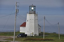
The headland of Cape St. Mary's is located at the southern tip of the south-western arm of the Avalon Peninsula of the island of Newfoundland in the Canadian province of Newfoundland and Labrador.
 Cape St. Mary's Lighthouse | |
 | |
| Location | Cape St. Mary's Avalon Peninsula Newfoundland Canada |
|---|---|
| Coordinates | 46°49′23.0″N 54°11′45.9″W / 46.823056°N 54.196083°W |
| Tower | |
| Constructed | 1860 |
| Foundation | concrete base |
| Construction | cast iron encased in concrete tower |
| Height | 11.5 metres (38 ft) |
| Shape | octagonal truncated tower with balcony and lantern |
| Markings | white tower, grey metallic lantern |
| Power source | solar power |
| Operator | Cape St. Mary's Ecological Reserve[1][2] |
| Heritage | heritage lighthouse, recognized federal heritage building of Canada |
| Fog signal | 1 blast every 30s. |
| Light | |
| Focal height | 119 metres (390 ft) |
| Range | 21 nautical miles (39 km; 24 mi) |
| Characteristic | Fl W 5s. |
Cape St. Mary's is probably one of the most well known capes of the province, it has been written in song and history. There is a well known folk song about the Cape called "Let Me Fish Off Cape St. Mary's" by Otto P. Kelland.
The Cape St. Mary's Ecological Reserve is a wildlife reserve located east of the Cape. The Friends of Cape St. Mary's is a non-profit organisation of persons who are engaged in sharing the colourful and diverse elements of the ecological reserve.
See also
editReferences
edit- ^ Rowlett, Russ. "Lighthouses of Canada: Southeastern Newfoundland". The Lighthouse Directory. University of North Carolina at Chapel Hill. Retrieved 2017-02-11.
- ^ List of Lights, Pub. 110: Greenland, The East Coasts of North and South America (Excluding Continental U.S.A. Except the East Coast of Florida) and the West Indies (PDF). List of Lights. United States National Geospatial-Intelligence Agency. 2016.
External links
edit- Aids to Navigation Canadian Coast Guard
- Let Me Fish Off Cape St. Mary's (lyrics)