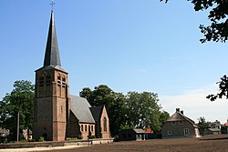
Capelle (also Kapelle[3]) is a village in the Dutch province of North Brabant. It is located about 6 km west of Waalwijk.
Capelle | |
|---|---|
Village | |
 Old St Willibrordus Church | |
| Coordinates: 51°41′32″N 4°59′7″E / 51.69222°N 4.98528°E | |
| Country | Netherlands |
| Province | North Brabant |
| Municipality | Waalwijk |
| Area | |
| • Total | 18.90 km2 (7.30 sq mi) |
| Elevation | 1.4 m (4.6 ft) |
| Population (2021)[1] | |
| • Total | 2,800 |
| • Density | 150/km2 (380/sq mi) |
| Time zone | UTC+1 (CET) |
| • Summer (DST) | UTC+2 (CEST) |
| Postal code | 5161[1] |
| Dialing code | 0416 |
The village was first mentioned in 1257 as Capella, and means chapel.[4] The original village was flooded in the St. Elizabeth's flood of 1421. The Dutch Reformed church dates from 1750 and has a wooden domed tower.[5]
Capelle was home to 144 people in 1840.[3] Capelle was a separate municipality until 1923, when it merged with Sprang and Vrijhoeve-Capelle. They formed the new municipality of Sprang-Capelle, which existed until 1997.[6] The village was flooded during the North Sea flood of 1953 and 42 people died. The municipality decided not to rebuild the village.[3] Since 1997 Capelle has been part of the municipality of Waalwijk.[6]
References
edit- ^ a b c "Kerncijfers wijken en buurten 2021". Central Bureau of Statistics. Retrieved 18 April 2022.
two entries
- ^ "Postcodetool for 5161AA". Actueel Hoogtebestand Nederland (in Dutch). Het Waterschapshuis. Retrieved 18 April 2022.
- ^ a b c "Capelle". Plaatsengids (in Dutch). Retrieved 18 April 2022.
- ^ "Capelle - (geografische naam)". Etymologiebank (in Dutch). Retrieved 18 April 2022.
- ^ Chris Kolman & Ronald Stenvert (1997). Capelle (in Dutch). Zwolle: Waanders. ISBN 90 400 9945 6. Retrieved 18 April 2022.
- ^ a b Ad van der Meer and Onno Boonstra, Repertorium van Nederlandse gemeenten, KNAW, 2011.

