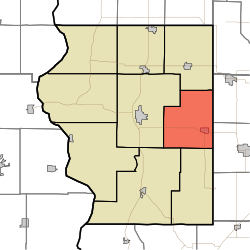
Cass Township is one of nine townships in Sullivan County, Indiana, USA. As of the 2020 census, its population was 1,856 and it contained 923 housing units.[1]
Cass Township | |
|---|---|
 Location in Sullivan County | |
| Coordinates: 39°05′07″N 87°17′40″W / 39.08528°N 87.29444°W | |
| Country | |
| State | |
| County | Sullivan |
| Government | |
| • Type | Indiana township |
| Area | |
• Total | 39.46 sq mi (102.2 km2) |
| • Land | 37.8 sq mi (98 km2) |
| • Water | 1.67 sq mi (4.3 km2) 4.23% |
| Elevation | 531 ft (162 m) |
| Population (2020) | |
• Total | 1,856 |
| • Density | 47/sq mi (18/km2) |
| ZIP codes | 47438, 47848, 47882 |
| GNIS feature ID | 453168 |
| Census | Pop. | Note | %± |
|---|---|---|---|
| 1890 | 2,356 | — | |
| 1900 | 2,819 | 19.7% | |
| 1910 | 4,759 | 68.8% | |
| 1920 | 5,488 | 15.3% | |
| 1930 | 4,304 | −21.6% | |
| 1940 | 4,044 | −6.0% | |
| 1950 | 3,063 | −24.3% | |
| 1960 | 2,443 | −20.2% | |
| 1970 | 2,263 | −7.4% | |
| 1980 | 2,454 | 8.4% | |
| 1990 | 1,912 | −22.1% | |
| 2000 | 1,932 | 1.0% | |
| 2010 | 2,074 | 7.3% | |
| 2020 | 1,856 | −10.5% | |
| Source: US Decennial Census[2] | |||
Geography
editAccording to the 2010 census, the township has a total area of 39.46 square miles (102.2 km2), of which 37.8 square miles (98 km2) (or 95.79%) is land and 1.67 square miles (4.3 km2) (or 4.23%) is water.[3]
Cities, towns, villages
editUnincorporated towns
edit- Baker at 39°07′50″N 87°18′45″W / 39.130598°N 87.312517°W
- Cass at 39°05′13″N 87°16′43″W / 39.086987°N 87.278627°W
- Gambill at 39°02′56″N 87°15′35″W / 39.048933°N 87.259737°W
- Greenville at 39°08′27″N 87°18′07″W / 39.140875°N 87.301961°W
- Hawton at 39°07′35″N 87°18′40″W / 39.126431°N 87.311128°W
- Jericho at 39°03′41″N 87°17′51″W / 39.061432°N 87.297516°W
- Scotchtown at 39°04′30″N 87°17′52″W / 39.075043°N 87.297794°W
- Shiloh at 39°02′20″N 87°17′33″W / 39.038932°N 87.292516°W
- Stringtown at 39°03′12″N 87°17′51″W / 39.053377°N 87.297516°W
(This list is based on USGS data and may include former settlements.)
Extinct towns
edit- Caledonia at 39°05′56″N 87°20′06″W / 39.098931°N 87.335017°W
- Farnsworth at 39°05′57″N 87°19′25″W / 39.099209°N 87.323628°W
(These towns are listed as "historical" by the USGS.)
Adjacent townships
edit- Jackson Township (north)
- Wright Township, Greene County (east)
- Stockton Township, Greene County (southeast)
- Jefferson Township (south)
- Haddon Township (southwest)
- Hamilton Township (west)
Cemeteries
editThe township contains these five cemeteries: Burris, Clayton Cemeteries (historical), Deckard, Dugger and Houck.
Major highways
editLakes
edit- Greenbriar Lake
School districts
edit- Northeast School Corporation
Political districts
edit- Indiana's 8th congressional district
- State House District 45
- State Senate District 39
References
edit- United States Census Bureau 2008 TIGER/Line Shapefiles
- United States Board on Geographic Names (GNIS)
- IndianaMap
- ^ "Explore Census Data". data.census.gov. Retrieved April 13, 2024.
- ^ "Township Census Counts: STATS Indiana".
- ^ "Population, Housing Units, Area, and Density: 2010 - County -- County Subdivision and Place -- 2010 Census Summary File 1". United States Census. Archived from the original on February 12, 2020. Retrieved May 10, 2013.