Chamigny (French pronunciation: [ʃamiɲi] ) is a commune in the Seine-et-Marne department in the Île-de-France region in north-central France.
Chamigny | |
|---|---|
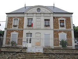
 The town hall in Chamigny | |
| Coordinates: 48°58′26″N 3°09′07″E / 48.9739°N 3.1519°E | |
| Country | France |
| Region | Île-de-France |
| Department | Seine-et-Marne |
| Arrondissement | Meaux |
| Canton | La Ferté-sous-Jouarre |
| Intercommunality | CA Coulommiers Pays de Brie |
| Government | |
| • Mayor (2023–2026) | Sylvie Le Breton[1] |
| Area 1 | 14.22 km2 (5.49 sq mi) |
| Population (2021)[2] | 1,378 |
| • Density | 97/km2 (250/sq mi) |
| Time zone | UTC+01:00 (CET) |
| • Summer (DST) | UTC+02:00 (CEST) |
| INSEE/Postal code | 77078 /77260 |
| Elevation | 50–198 m (164–650 ft) |
| 1 French Land Register data, which excludes lakes, ponds, glaciers > 1 km2 (0.386 sq mi or 247 acres) and river estuaries. | |
It is located in the Marne valley in a wooded setting, east of the main D603 road.
The inhabitants are called Chamignots.
Sights and monuments
editThe Château de Tanqueux manor house dates back to 1488, and the parish church of St Étienne to 1130.[3]
The gardens of the Château de Tanqueux were laid out in 1805. Privately owned, they are not open to the public.[4] The parish church was modified in the 13th and 14th centuries. It has been classified since 1981 as a monument historique by the French Ministry of Culture.[5]
See also
editReferences
edit- ^ "Répertoire national des élus: les maires" (in French). data.gouv.fr, Plateforme ouverte des données publiques françaises. 6 June 2023.
- ^ "Populations légales 2021" (in French). The National Institute of Statistics and Economic Studies. 28 December 2023.
- ^ "Commune de Chamigny".
- ^ Base Mérimée: Jardin d'agrément dit parc du château de Tanqueux, Ministère français de la Culture. (in French)
- ^ Base Mérimée: Eglise Saint-Etienne, Ministère français de la Culture. (in French)
External links
editWikimedia Commons has media related to Chamigny.
- 1999 Land Use, from IAURIF (Institute for Urban Planning and Development of the Paris-Île-de-France région) (in English)
- Base Mérimée: Search for heritage in the commune, Ministère français de la Culture. (in French)


