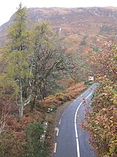
The Corraun Peninsula, also spelt Currane (Irish:An Corrán [1]), is a peninsula in County Mayo, on the west coast of Ireland. It extends out from the mainland towards Achill Island.
Native name: An Corrán | |
|---|---|
 Achill Island and to the east, Corraun Peninsula | |
 | |
| Geography | |
| Location | County Mayo, Ireland |
| Demographics | |
| Population | 726 (2016) |
| Languages | Irish |

Thoroughfares on the peninsula include the Great Western Greenway, which passes through the north side of the peninsula, following a scenic route.[citation needed]
As of 2016 the population of the Corraun peninsula was 726.[2] The entire peninsula is in the Gaeltacht (designated Irish speaking region)[3] with 12% of the population claiming to speak Irish on a daily basis outside the education system.[4] The peninsula is immediately east of Achill Island, and forms part of the parish of Achill. It comprises the villages of Tornragee, Polranny, Belfarsad, Corraun (Currane) and Dogh Beg.
Achill Island is connected to the peninsula via the Michael Davitt Bridge.
Corraun is dominated by Corraun Hill (524 m).[5] There are views of Clew Bay and the Mullet Peninsula to the north.[citation needed]
Sport
editCorraun is the home of Fr Griffin Park, the Community Sports Field overlooking views of Croagh Patrick, Achillbeg Island and Clare Island. It hosts rugby, Gaelic football, and soccer matches.[citation needed]
Mulranny United Football Club play all their home league games here. In the past it has also hosted Achill Rovers.[citation needed]
Gallery
edit-
The castle and Corraun Hill
-
Sheep in a paddock by the Great Western Greenway near Mulranny. November 2014
References
edit- ^ "An Corrán / Corraun Peninsula". logainm.ie. Retrieved 18 November 2021.
- ^ "ArcGIS Web Application". airomaps.nuim.ie. Retrieved 21 November 2020.
- ^ "Gaeltacht Boundaries Generalised to 50m". census2016.geohive.ie. Retrieved 21 November 2020.
- ^ "ArcGIS Web Application". census.cso.ie. Archived from the original on 28 November 2017. Retrieved 21 November 2020.
- ^ Mayo map 1838, Mayo library web site
53°55′02″N 9°51′52″W / 53.9171°N 9.8644°W