You can help expand this article with text translated from the corresponding article in Korean. (July 2020) Click [show] for important translation instructions.
|
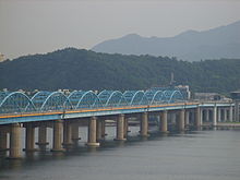
The Dongjak Bridge (Korean: 동작대교) is a bridge over the Han River in Seoul, South Korea. It carries road traffic and Seoul Subway Line 4, and Dongjak Station is located at the southern end of this bridge. It is a blue truss bridge.[1] It is the 11th bridge overall, and the fifth railroad bridge to be completed across the Han River. Dongjakdaegyo was completed on the same day as Donghodaegyo, which has a similar structure.
| Dongjak Bridge | |
 Dongjakdaegyo | |
| Korean name | |
|---|---|
| Hangul | 동작대교 |
| Hanja | |
| Revised Romanization | Dongjakdaegyo |
| McCune–Reischauer | Tongjaktaegyo |
History
editConstruction on Dongjakdaegyo commenced on October 18, 1978, and Seoul Mayor Jachoon Gu, Deputy Prime Minister Deokwoo Nam, and Minister of Construction Hyeongshik Shin participated in the groundbreaking ceremony. At the time of commencing construction, Dongjakdaegyo was the first bridge in Korea to have the langer-arch design, and was scheduled to open in September 1981. The reason for using the langer-arch design for this bridge was because a steel plate was used instead of a concrete plate for reducing the bridge weight by designing to allow the Seoul Line No. 4 to pass. At the time, the construction of Dongjakdaegyo was carried out as construction of a civil investment method by the investment and construction delegated to Daewoo Development, similar to Wonhyo Daegyo, therefore there was a plan to receive toll fares for a period of 20 years. At the time of construction, Dongjakdaegyo was the widest bridge in Korea.
- October 18, 1978: Construction started
- February 1980: Construction completion time extended to December 1981
- 1981: Construction suspended due to Daewoo Construction returning the construction project
- February 1982: Construction resumed
- December 1983: Construction completion time extended to the end of 1984
- February 1984: Announcement of plan to open in September with only six vehicle lanes
- November 14, 1984: Completed and opened
References
edit- ^ (in Korean) 동작대교 銅雀大橋 (Dongjak Bridge) Archived June 10, 2011, at the Wayback Machine Nate / EncyKorea, retrieved on July 13, 2009
37°30′40″N 126°58′56″E / 37.5112°N 126.9822°E