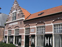
Driewegen is a village in the Dutch province of Zeeland. It is a part of the municipality of Borsele, and lies about 16 km southeast of Middelburg. Until 1970 it was an independent municipality.
Driewegen | |
|---|---|
Village | |
 Former town hall | |
| Coordinates: 51°25′3″N 3°48′12″E / 51.41750°N 3.80333°E | |
| Country | Netherlands |
| Province | Zeeland |
| Municipality | Borsele |
| Area | |
• Total | 6.18 km2 (2.39 sq mi) |
| Elevation | 1.3 m (4.3 ft) |
| Population (2021)[1] | |
• Total | 560 |
| • Density | 91/km2 (230/sq mi) |
| Time zone | UTC+1 (CET) |
| • Summer (DST) | UTC+2 (CEST) |
| Postal code | 4438[1] |
| Dialing code | 0113 |
History
editThe village was first mentioned in 1505 as ten Drienwegen, and means intersection of three roads.[3] The polder which contains Driewegen was created around 1300, and a village has been known to exist since 1351.[4]
The Dutch Reformed church was built in 1678. The interior of the church was modified during the restoration of 1911 until 1914. The former town hall was located in a modified school building from 1913.[4]
Driewegen was home to 443 people in 1840.[5] In 1927, a joint railway station with Ovezande was built on the Goes to Hoedekenskerke railway line. It closed in 1934.[6]
Driewegen was an independent municipality until 1970 when it was merged into Borsele.[5]
Gallery
edit-
Farm Geertruidshoeve
-
Former railway station
-
Dutch Reformed church
References
edit- ^ a b c "Kerncijfers wijken en buurten 2021". Central Bureau of Statistics. Retrieved 19 April 2022.
- ^ "Postcodetool for 4438AA". Actueel Hoogtebestand Nederland (in Dutch). Het Waterschapshuis. Retrieved 19 April 2022.
- ^ "Driewegen - (geografische naam)". Etymologiebank (in Dutch). Retrieved 19 April 2022.
- ^ a b Piet van Cruyningen & Ronald Stenvert (2003). Driewegen (in Dutch). Zwolle: Waanders. ISBN 90 400 8830 6. Retrieved 19 April 2022.
- ^ a b "Driewegen". Plaatsengids (in Dutch). Retrieved 19 April 2022.
- ^ "station Driewegen- Ovezande". Stationsweb (in Dutch). Retrieved 19 April 2022.


