Eagle's Nest (Chinese: 鷹巢山), also known indigenously as Tsim Shan (尖山), is a hill north of Cheung Sha Wan of Hong Kong. The hill is located within Lion Rock County Park, and administratively part of Sha Tin District with border to Sham Shui Po District at her south.[1] The hill peaks at 305 metres and is within . The hill is located northeast of Piper's Hill and northwest of Crow's Nest.
| Eagle's Nest, Hong Kong | |
|---|---|
| 尖山 | |
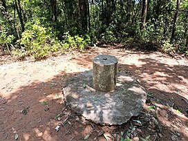
 Trigonometrical station at the summit of Eagle's Nest | |
| Highest point | |
| Elevation | 305 m (1,001 ft) |
| Coordinates | 22°20′47.29″N 114°9′37.43″E / 22.3464694°N 114.1603972°E |
| Geography | |
| Location | |
Conservation
editThe steep north face of Beacon Hill, together with a valley to the north-east of Eagle's Nest, covering a total area of 53.2 hectares, was designated as a Site of Special Scientific Interest in 1979.[2][3]
Access
editEagle's Nest Nature Trail goes around her peak while the Stage 5 of MacLehose Trail runs on her north.[4][5]
Transport
editThe hill is the site of Eagle's Nest Tunnel, a major infrastructure project in the area.
References
edit- ^ Hong Kong Agriculture, Fisheries and Conservation Department. "Lion Rock". Retrieved 2024-07-02.
- ^ "Register of Sites of Special Scientific Interest (SSSIs)". Planning Department. Archived from the original on 2023-08-16.
- ^ "Site of Special Scientific Interest - Beacon Hill" (PDF). Planning Department. 30 September 1992.
- ^ Tang, Timothy. "Traffic Statistics - Eagle's Nest Tunnel and Sha Tin Heights Tunnel". Hong Kong Transport Department. Retrieved 9 January 2019.
- ^ "Sha Tin Pass Road to Kowloon Reservoir | Hong Kong Tourism Board". www.discoverhongkong.com. Retrieved 2020-04-05.
