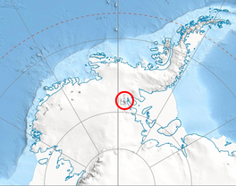
The Ellen Glacier is a glacier in the central Sentinel Range of the Ellsworth Mountains of Antarctica. It drains the eastern slopes of Mount Anderson and Long Gables and flows generally southeast for 22 nautical miles (41 km; 25 mi) to Barnes Ridge, where it leaves the range and enters the south flowing Rutford Ice Stream.
| Ellen Glacier | |
|---|---|
 Location of Sentinel Range in Western Antarctica | |
Location of Ellen Glacier in Antarctica | |
| Location | Ellsworth Land |
| Coordinates | 78°13′S 84°30′W / 78.217°S 84.500°W |
| Length | 22 nautical miles (41 km; 25 mi) |
| Thickness | unknown |
| Terminus | Rutford Ice Stream |
| Status | unknown |

It was first mapped by the United States Geological Survey from surveys and U.S. Navy air photos, 1957–59, and was named by the Advisory Committee on Antarctic Names for Lieutenant Colonel Cicero J. Ellen of the U.S. Air Force, who was in command of many of the air operations when the South Pole Station was established by air drop in the 1956–57 season.[1]
Tributary glaciers
editSee also
editExternal links
edit- Ellen Glacier. Copernix satellite image
References
edit- ^ "Ellen Glacier". Geographic Names Information System. United States Geological Survey, United States Department of the Interior. Retrieved 28 February 2012.
- This article incorporates public domain material from "Ellen Glacier". Geographic Names Information System. United States Geological Survey.
78°13′S 84°30′W / 78.217°S 84.500°W
