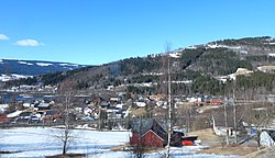
Fåberg is a village in Lillehammer Municipality in Innlandet county, Norway. The village is located in the Gudbrandsdalen valley, along the shore of the Gudbrandsdalslågen river. The town of Lillehammer lies about 5 kilometres (3.1 mi) to the southeast of Fåberg and the village of Jorstadmoen lies about 3 kilometres (1.9 mi) to the southwest of Fåberg. The European route E6 highway and the Dovrebanen railway line both run through the village. The historic Fåberg Church lies a short distance west of the village, on the other side of the river.[3]
Fåberg | |
|---|---|
Village | |
 View of the village | |
| Coordinates: 61°10′06″N 10°24′17″E / 61.16836°N 10.40479°E | |
| Country | Norway |
| Region | Eastern Norway |
| County | Innlandet |
| District | Gudbrandsdalen |
| Municipality | Lillehammer Municipality |
| Area | |
| • Total | 0.52 km2 (0.20 sq mi) |
| Elevation | 155 m (509 ft) |
| Population (2021)[1] | |
| • Total | 696 |
| • Density | 1,347/km2 (3,490/sq mi) |
| Time zone | UTC+01:00 (CET) |
| • Summer (DST) | UTC+02:00 (CEST) |
| Post Code | 2625 Fåberg |

The 0.52-square-kilometre (130-acre) village has a population (2021) of 696 and a population density of 1,347 inhabitants per square kilometre (3,490/sq mi).[1]
From 1838 to 1964, the village of Fåberg was the administrative centre of the old Fåberg Municipality. In 1964, it was merged into Lillehammer Municipality.
Name
editThe village was named after the nearby Fåberg farm (Old Norse: Fágaberg) because the first Fåberg Church was built there. The meaning of the first element is unknown. The last element is berg which means "mountain". Prior to 1921, the name was spelled "Faaberg".[3]
References
edit- ^ a b c Statistisk sentralbyrå (1 January 2021). "Urban settlements. Population and area, by municipality".
- ^ "Fåberg, Lillehammer". yr.no. Retrieved 3 July 2022.
- ^ a b Thorsnæs, Geir, ed. (29 March 2022). "Fåberg". Store norske leksikon (in Norwegian). Kunnskapsforlaget. Retrieved 3 July 2022.

