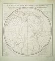
File:A chart of the southern hemisphere; shewing the tracks of some of the most distinguished navigators- by Captain James Cook, of His Majesty's navy. RMG F1972.tiff

Original file (5,653 × 6,247 pixels, file size: 101.04 MB, MIME type: image/tiff)

Summary

Author
Captain James Cook; William Strahan and Thomas Cadell; William Whitchurch
Description
English: A chart of the southern hemisphere; shewing the tracks of some of the most distinguished navigators: by Captain James Cook, of His Majesty's navy.Single sheet, engraving. Polar projection. The chart shows the tracks of Mendana in 1595, Quiros in 1606, Le Maire & Schouten in 1616, Tasman in 1642, Halley in 1700, Roggewein in 1722, Bouvet in 1738-39, Byron in 1765, Wallis in 1767, Bougainville in 1768, Surville in 1769, and Cook's first and second voyages. Tables in the corners contain the latitudes and longitudes of the islands lately discovered in the South Pacific Ocean, as they are laid down in this chart. Chart to show Cook's track and discoveries, plate 1 from the 2nd vol of his A Voyage Towards the South Pole.
G201:3/1 (2) Southern Hemisphere by Cook
Date 1777
date QS:P571,+1777-00-00T00:00:00Z/9
Dimensions Printed area 56.5 x 54.5cm, on sheet 67 x 62cm.
Source/Photographer http://collections.rmg.co.uk/collections/objects/540221
Permission
(Reusing this file)

The original artefact or artwork has been assessed as public domain by age, and faithful reproductions of the two dimensional work are also public domain. No permission is required for reuse for any purpose.

The text of this image record has been derived from the Royal Museums Greenwich catalogue and image metadata. Individual data and facts such as date, author and title are not copyrightable, but reuse of longer descriptive text from the catalogue may not be considered fair use. Reuse of the text must be attributed to the "National Maritime Museum, Greenwich, London" and a Creative Commons CC-BY-NC-SA-3.0 license may apply if not rewritten. Refer to Royal Museums Greenwich copyright.
Identifier
InfoField
id number: G201:3/1(2)
Collection
InfoField
Charts and maps

Licensing

This is a faithful photographic reproduction of a two-dimensional, public domain work of art. The work of art itself is in the public domain for the following reason:
Public domain

This work is in the public domain in its country of origin and other countries and areas where the copyright term is the author's life plus 100 years or fewer.


This work is in the public domain in the United States because it was published (or registered with the U.S. Copyright Office) before January 1, 1929.

This file has been identified as being free of known restrictions under copyright law, including all related and neighboring rights.
The official position taken by the Wikimedia Foundation is that "faithful reproductions of two-dimensional public domain works of art are public domain".
This photographic reproduction is therefore also considered to be in the public domain in the United States. In other jurisdictions, re-use of this content may be restricted; see Reuse of PD-Art photographs for details.

Captions

Add a one-line explanation of what this file represents

Items portrayed in this file

depicts

image/tiff

ae5b54ca17813f47341fdea61659793c3ac92f14

105,943,013 byte

6,247 pixel

5,653 pixel

File history

Click on a date/time to view the file as it appeared at that time.

Date/TimeThumbnailDimensionsUserComment
current02:23, 27 August 2017Thumbnail for version as of 02:23, 27 August 20175,653 × 6,247 (101.04 MB)Royal Museums Greenwich Charts and maps, http://collections.rmg.co.uk/collections/objects/540221

The following page uses this file:

Metadata