File:A map of the most inhabited part of Virginia containing the whole province of Maryland - with part of Pensilvania, New Jersey and North Carolina - drawn by Joshua Fry and Peter Jefferson in 1775. NYPL434595.tiff

Size of this JPG preview of this TIF file: 800 × 587 pixels. Other resolutions: 320 × 235 pixels | 640 × 470 pixels | 1,024 × 752 pixels | 1,280 × 940 pixels | 2,560 × 1,880 pixels | 9,322 × 6,845 pixels.
Original file (9,322 × 6,845 pixels, file size: 182.56 MB, MIME type: image/tiff)
| This is a file from the Wikimedia Commons. Information from its description page there is shown below. Commons is a freely licensed media file repository. You can help. |
Summary
| Description | A map of the most inhabited part of Virginia containing the whole province of Maryland : with part of Pensilvania, New Jersey and North Carolina / drawn by Joshua Fry and Peter Jefferson in 1775.; Maps of North America. / Countries / United States (except New York) / Parts | |||||||||||||||||||||||
| Notes | "To the Right Honourable, George Dunk, Earl of Halifax ... This map is most humbly inscribed ... by ... Tho's Jefferys. " ''Note 2.'') Appears in Thomas Jefferys' American atlas. ''Note 3.'') Described in: Fry and Jefferson map of Virginia and Maryland : facsimiles of the 1754 and 1794 printings. 1966. p. [21]. ''Note 4.'') Includes distance chart and ill. ''Note 5.'') National Endowment for the Humanities Grant for Access to Early Maps of the Middle Atlantic Seaboard. ''Note 6.'') NYPL copy mounted on muslin. ''Note 7.'') Outline color. ''Note 8.'') Prime meridian: Philadelphia and Curratuck Inlet. ''Note 9.'') Relief shown pictorially. ''Note 10.'') Sheets numbered on verso: 21 -- 22. ''Note 11.'') This version differs from similar versions, because of omission of Jefferys' name and address from the imprint. | |||||||||||||||||||||||
| Catalogue call number | Map Div. 00-346 | |||||||||||||||||||||||
| Standard reference | Variant of Cumming 449 | |||||||||||||||||||||||
| Date | ||||||||||||||||||||||||
| Source |
http://digitalgallery.nypl.org/nypldigital/dgkeysearchdetail.cfm?imageID=434595
|
|||||||||||||||||||||||
| Author | Sayer, Robert, 1725-1794 -- Publisher | |||||||||||||||||||||||
| Permission (Reusing this file) |
From The Lionel Pincus and Princess Firyal Map Division. http://maps.nypl.org
|
|||||||||||||||||||||||
| Location | Stephen A. Schwarzman Building / The Lionel Pincus and Princess Firyal Map Division | |||||||||||||||||||||||
| Digital item published | 2-3-2004; updated 3-25-2011 | |||||||||||||||||||||||
| Digital ID | 434595 | |||||||||||||||||||||||

The making of this file was supported by Wikimedia UK.
To see other files made with the support of Wikimedia UK, please see the category Supported by Wikimedia UK.
|
File history
Click on a date/time to view the file as it appeared at that time.
| Date/Time | Thumbnail | Dimensions | User | Comment | |
|---|---|---|---|---|---|
| current | 10:42, 20 April 2014 | 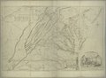 | 9,322 × 6,845 (182.56 MB) | Fæ | GWToolset:: Creating mediafile for Fæ. Tranche 2.590 |
File usage
The following pages on the English Wikipedia use this file (pages on other projects are not listed):
Global file usage
The following other wikis use this file:
- Usage on azb.wikipedia.org