File:A portion of Fort Leaton, a Texas State Historic Site, on the edge of Presidio, along the Rio Grande River in Brewster County, Texas LCCN2014630294.tif

Size of this JPG preview of this TIF file: 800 × 534 pixels. Other resolutions: 320 × 214 pixels | 640 × 427 pixels | 1,024 × 683 pixels | 1,280 × 854 pixels | 2,560 × 1,709 pixels | 7,360 × 4,912 pixels.
Original file (7,360 × 4,912 pixels, file size: 206.9 MB, MIME type: image/tiff)
| This is a file from the Wikimedia Commons. Information from its description page there is shown below. Commons is a freely licensed media file repository. You can help. |
Summary
| Description |
English: Title: A portion of Fort Leaton, a Texas State Historic Site, on the edge of Presidio, along the Rio Grande River in Brewster County, Texas
Physical description: 1 photograph : digital, tiff file, color. Notes: Title, date, and keywords based on information provided by the photographer.; Gift; The Lyda Hill Foundation; 2014; (DLC/PP-2014:054).; The adobe structure, which now serves as the western-side visitor center for BIg Bend Ranch State Park, was built in the 1830s and purchased by a prominent Anglo-American landholder, Ben Leaton, who expanded it into fortress dimensions and made it his home. What came to be called "Fort Leaton," though, contrary to erroneous local lore, it was never a Spanish fortification, was also Presidio County's first seat of government.; Forms part of: Lyda Hill Texas Collection of Photographs in Carol M. Highsmith's America Project in the Carol M. Highsmith Archive.; Credit line: The Lyda Hill Texas Collection of Photographs in Carol M. Highsmith's America Project, Library of Congress, Prints and Photographs Division. |
||||||||||||||||||||||||||
| Date | Taken on 17 March 2014, 17:53 (according to Exif data) | ||||||||||||||||||||||||||
| Source |
Library of Congress
|
||||||||||||||||||||||||||
| Author |
|
||||||||||||||||||||||||||
| Permission (Reusing this file) |
No known restrictions on publication.
|
||||||||||||||||||||||||||
| Other versions |
|
||||||||||||||||||||||||||


| Camera location | | View this and other nearby images on: OpenStreetMap |
|---|
Licensing
| This work is from the Carol M. Highsmith Archive collection at the Library of Congress. According to the library, there are no known copyright restrictions on the use of this work. Carol M. Highsmith has stipulated that her photographs are in the public domain. Photographs of sculpture or other works of art may be restricted by the copyright of the artist; see Commons:FOP US#Artworks and sculptures for more information. |
 |
File history
Click on a date/time to view the file as it appeared at that time.
| Date/Time | Thumbnail | Dimensions | User | Comment | |
|---|---|---|---|---|---|
| current | 16:32, 5 September 2016 |  | 7,360 × 4,912 (206.9 MB) | Fæ | LOC 2014630294, Carol M. Highsmith collection. P41.10360 TIFF (206.9mb) |
| 16:32, 5 September 2016 | 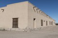 | 7,360 × 4,912 (206.9 MB) | Fæ | LOC 2014630294, Carol M. Highsmith collection. P41.10360 TIFF (206.9mb) |
File usage
No pages on the English Wikipedia use this file (pages on other projects are not listed).