File:In 2005, this 24-foot statue of Shoshone Indian chief Washakie, by Cody, Wyoming, sculptor Dave McGary, was unveiled on the University of Wyoming campus in Laramie LCCN2015632807.tif

Size of this JPG preview of this TIF file: 554 × 600 pixels. Other resolutions: 222 × 240 pixels | 443 × 480 pixels | 709 × 768 pixels | 946 × 1,024 pixels | 1,891 × 2,048 pixels | 4,912 × 5,319 pixels.
Original file (4,912 × 5,319 pixels, file size: 149.54 MB, MIME type: image/tiff)
| This is a file from the Wikimedia Commons. Information from its description page there is shown below. Commons is a freely licensed media file repository. You can help. |
Summary
| Description |
English: Title: In 2005, this 24-foot statue of Shoshone Indian chief Washakie, by Cody, Wyoming, sculptor Dave McGary, was unveiled on the University of Wyoming campus in Laramie
Physical description: 1 photograph : digital, tiff file, color. Notes: Forms part of: Gates Frontiers Fund Wyoming Collection within the Carol M. Highsmith Archive.; Credit line: Gates Frontiers Fund Wyoming Collection within the Carol M. Highsmith Archive, Library of Congress, Prints and Photographs Division.; The statue depicts Chief Washakie on horseback at the Battle of Crowheart Butte. The last chief of the Shoshone tribe, Washakie is remembered as a statesman, a respected warrior and a champion of education for his people. A different statue of Chief Washakie, also by McGary, was dedicated in the United States Capitol statuary hall five years earlier.; Title, date and keywords based on information provided by the photographer.; Purchase; Carol M. Highsmith Photography, Inc.; 2015; (DLC/PP-2015:069). |
||||||||||||||||||||||||||
| Date | Taken on 7 June 2015, 11:40 (according to Exif data) | ||||||||||||||||||||||||||
| Source |
Library of Congress
|
||||||||||||||||||||||||||
| Author |
|
||||||||||||||||||||||||||
| Permission (Reusing this file) |
No known restrictions on publication.
|
||||||||||||||||||||||||||


| Camera location | | View this and other nearby images on: OpenStreetMap |
|---|
Licensing
| This work is from the Carol M. Highsmith Archive collection at the Library of Congress. According to the library, there are no known copyright restrictions on the use of this work. Carol M. Highsmith has stipulated that her photographs are in the public domain. Photographs of sculpture or other works of art may be restricted by the copyright of the artist; see Commons:FOP US#Artworks and sculptures for more information. |
 |
File history
Click on a date/time to view the file as it appeared at that time.
| Date/Time | Thumbnail | Dimensions | User | Comment | |
|---|---|---|---|---|---|
| current | 12:10, 30 September 2016 | 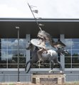 | 4,912 × 5,319 (149.54 MB) | Fæ | LOC 2015632807, Carol M. Highsmith collection. P46.23685 TIFF (149.5mb) |
File usage
The following pages on the English Wikipedia use this file (pages on other projects are not listed):