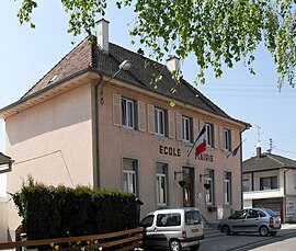
Frœningen (French pronunciation: [frøniŋ(ɡ)ən] ; German: Fröningen) is a commune in the Haut-Rhin department in Alsace in north-eastern France.
Frœningen | |
|---|---|
 The town hall and school in Frœningen | |
| Coordinates: 47°41′29″N 7°16′14″E / 47.6914°N 7.2706°E | |
| Country | France |
| Region | Grand Est |
| Department | Haut-Rhin |
| Arrondissement | Altkirch |
| Canton | Altkirch |
| Government | |
| • Mayor (2020–2026) | Georges Heim[1] |
| Area 1 | 4.44 km2 (1.71 sq mi) |
| Population (2021)[2] | 849 |
| • Density | 190/km2 (500/sq mi) |
| Time zone | UTC+01:00 (CET) |
| • Summer (DST) | UTC+02:00 (CEST) |
| INSEE/Postal code | 68099 /68720 |
| Elevation | 252–305 m (827–1,001 ft) (avg. 260 m or 850 ft) |
| 1 French Land Register data, which excludes lakes, ponds, glaciers > 1 km2 (0.386 sq mi or 247 acres) and river estuaries. | |
History
editIn 1312, Count Ulrich de Ferrette yielded Frœningen to Knight Conrad of Flaxlanden. The village was later ceded to Hadmansdorf in 1458, then to the noble family of Reinach-Heidwiller in 1539. During the Thirty Years' War, the castle was spared, but was finally set on fire by the Swiss in 1468. It was rebuilt in the eighteenth century, but was burned again, following the negligence of a cook, in 1739.
The castle was rebuilt in the early nineteenth century, but fell under the bombings of the First World War in 1917.
The village had a large Jewish community at the end of the nineteenth century and bore the nickname of Little Switzerland.[3]
See also
editReferences
edit- ^ "Répertoire national des élus: les maires". data.gouv.fr, Plateforme ouverte des données publiques françaises (in French). 2 December 2020.
- ^ "Populations légales 2021" (in French). The National Institute of Statistics and Economic Studies. 28 December 2023.
- ^ Zosa Szajkowski (1970). Jews and the French Revolutions of 1789, 1830 and 1848. KTAV Publishing House, Inc., 1970. ISBN 9780870680007.


