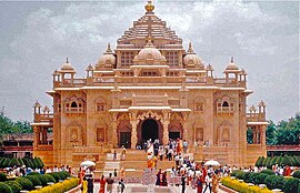
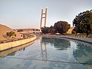
Gandhinagar (/ɡɑːndɪˈnɑːɡər/, Gujarati: [ˈgɑːndʱinəgəɾ] ) is the capital of the state of Gujarat in India. Gandhinagar is located approximately 23 km north of Ahmedabad, on the west central point of the industrial corridor between the megacities of Delhi and Mumbai.
Gandhinagar | |
|---|---|
Clockwise, from top: Akshardham temple, Gandhinagar Capital railway station Overview, Gujarat Science City, Mahatma Mandir | |
 Logo of the Gandhinagar Municipal Corporation | |
| Country | |
| State | |
| District | Gandhinagar |
| Region | North Gujarat |
| Named for | Mahatma Gandhi |
| Government | |
| • Type | Mayor–Council |
| • Body | Gandhinagar Municipal Corporation |
| • Municipal Commissioner | Ratankanvar H. Gadhavicharan |
| • Mayor | Rita Patel |
| Area | |
• Total | 326 km2 (126 sq mi) |
| Elevation | 81 m (266 ft) |
| Population (2011)[2] | |
• Total | 292,167 |
| • Density | 900/km2 (2,300/sq mi) |
| Languages | |
| • Official | Gujarati, Hindi, and English |
| Time zone | UTC+5:30 (IST) |
| PIN CODE | 382010[3] |
| Telephone code | 079[4] |
| Vehicle registration | GJ-18 |
| Website | gujaratindia |
Gandhinagar lies on the west bank of the Sabarmati River, about 545 km (338 miles) north of Mumbai and 901 km (560 miles) southwest of Delhi.[5] The Akshardham temple is located in Gandhinagar.[6] There was a determination to make Gandhinagar a purely Indian enterprise, partly because the state of Gujarat was the birthplace of Mahatma Gandhi. For this reason, the planning was done by two Indian town planners: Prakash M Apte and H. K. Mewada, who had apprenticed with Le Corbusier in Chandigarh.[7]
Etymology
The name of the city means "Gandhi's city" and it is named after Mahatma Gandhi.[8]
History
The city was planned by Chief Architect H.K. Mewada, a Cornell University graduate, and his assistant Prakash M Apte.[9][10][when?] It was developed in the 1960s.
Demographics
According to the 2011[update] census of India, Gandhinagar had a population of 208,299. Males constitute 53% of the population and females 47%. Gandhinagar has an average literacy rate of 90%. Male literacy is 91%, and female literacy is 89%. In Gandhinagar, 11% of the population is under 6 years of age. Over 95% of the population of Gandhinagar are Hindus.[11]
Geography
Gandhinagar has an average elevation of 81 metres (266 feet). The city sits on the banks of the Sabarmati River, in north-central-east Gujarat. The 20,543 km2 area around Gandhinagar is defined by Gujarat capital territory. Gandhinagar spans an area of 326 km2 (126 sq mi).[1] The river frequently dries up in the summer, leaving only a small stream of water. Gandhinagar is India's tree capital with 54% green cover on its land area.[12]
Climate
| Gandhinagar | ||||||||||||||||||||||||||||||||||||||||||||||||||||||||||||
|---|---|---|---|---|---|---|---|---|---|---|---|---|---|---|---|---|---|---|---|---|---|---|---|---|---|---|---|---|---|---|---|---|---|---|---|---|---|---|---|---|---|---|---|---|---|---|---|---|---|---|---|---|---|---|---|---|---|---|---|---|
| Climate chart (explanation) | ||||||||||||||||||||||||||||||||||||||||||||||||||||||||||||
| ||||||||||||||||||||||||||||||||||||||||||||||||||||||||||||
| ||||||||||||||||||||||||||||||||||||||||||||||||||||||||||||
Gandhinagar has a tropical wet and dry climate with three main seasons: summer, monsoon and winter. The climate is generally dry and hot outside of the monsoon season. The weather is hot to severely hot from March to May when the maximum temperature stays in the range of 36 to 42 °C (97 to 108 °F), and the minimum in the range of 19 to 27 °C (66 to 81 °F). It is pleasant in the winter days and quite chilling in the night during December to February. The average maximum temperature is around 29 °C (84 °F), the average minimum is 13 °C (55 °F), and the climate is extremely dry. The southwest monsoon brings a humid climate from mid-June to mid-September.[14] The average annual rainfall is around 773.6 mm (30.46 in).
| Climate data for Gandhinagar (1991–2020) | |||||||||||||
|---|---|---|---|---|---|---|---|---|---|---|---|---|---|
| Month | Jan | Feb | Mar | Apr | May | Jun | Jul | Aug | Sep | Oct | Nov | Dec | Year |
| Record high °C (°F) | 34.5 (94.1) |
38.1 (100.6) |
43.2 (109.8) |
44.6 (112.3) |
48.0 (118.4) |
45.0 (113.0) |
40.5 (104.9) |
36.7 (98.1) |
41.0 (105.8) |
39.2 (102.6) |
37.4 (99.3) |
36.5 (97.7) |
48.0 (118.4) |
| Mean daily maximum °C (°F) | 27.8 (82.0) |
31.0 (87.8) |
35.9 (96.6) |
39.4 (102.9) |
41.8 (107.2) |
38.9 (102.0) |
33.4 (92.1) |
31.8 (89.2) |
33.2 (91.8) |
35.2 (95.4) |
32.5 (90.5) |
29.4 (84.9) |
34.6 (94.3) |
| Mean daily minimum °C (°F) | 11.6 (52.9) |
14.7 (58.5) |
19.1 (66.4) |
24.0 (75.2) |
27.9 (82.2) |
28.5 (83.3) |
26.6 (79.9) |
25.7 (78.3) |
25.2 (77.4) |
21.8 (71.2) |
17.2 (63.0) |
12.4 (54.3) |
21.6 (70.9) |
| Record low °C (°F) | 3.6 (38.5) |
3.1 (37.6) |
7.0 (44.6) |
14.5 (58.1) |
19.2 (66.6) |
19.0 (66.2) |
21.3 (70.3) |
20.0 (68.0) |
19.4 (66.9) |
12.5 (54.5) |
7.6 (45.7) |
4.4 (39.9) |
3.1 (37.6) |
| Average rainfall mm (inches) | 0.5 (0.02) |
0.0 (0.0) |
0.8 (0.03) |
0.7 (0.03) |
1.3 (0.05) |
91.0 (3.58) |
284.1 (11.19) |
270.8 (10.66) |
109.5 (4.31) |
12.5 (0.49) |
1.8 (0.07) |
0.6 (0.02) |
773.6 (30.46) |
| Average rainy days | 0.1 | 0.0 | 0.1 | 0.1 | 0.0 | 3.6 | 10.9 | 10.3 | 5.4 | 1.0 | 0.3 | 0.1 | 31.9 |
| Source: India Meteorological Department[15] | |||||||||||||
Governance and politics
On 1 May 1960, Gujarat was created out of the 17 northern districts of the former State of Bombay. These districts were further subdivided later on. There are 33 administrative districts in the state. Gandhinagar is a political hub for the state of Gujarat.[16][17]
Congress won the first municipal election in 2011.[18] Mahendrasinh Rana became the first mayor of the city. The current Member of the Lok Sabha for Gandhinagar is Amit Shah from the Bharatiya Janata Party (BJP).[19]
Gandhinagar is also situated near the west command post of the Indian Army and Indian Air force and also has a command centre in the city.
Gandhinagar has recently developed the Gujarat State Emergency Disaster Management centre.
Transport
Air
Sardar Vallabhbhai Patel International Airport located in Ahmedabad is 18 km away from Gandhinagar, providing both domestic and international flights.
Rail
Gandhinagar Capital railway station (GNC) is located in Sector 14. Many trains running on the western zones pass through Gandhinagar. Currently, there are five trains running from this station in which three are express trains and two are MEMU trains. Jaipur-Bandra Garib Rath, Haridwar mail for Delhi and Haridwar and Shanti Express for Indore Junction BG are main express trains running through this station.
Ahmedabad Railway Station (ADI) in Kalupur Ahmedabad is the nearest rail junction (25 km away) which provides connectivity with all the major cities and towns of India. The Indian Railways transports are available for moving in northern India and eastern India from Kalol Junction railway station (KLL).
-
Gandhinagar City Bus
-
Indian Institute of Technology Gandhinagar
-
Mahatma Mandir as seen from Swarnim Park
Metro
Under Phase II of the Ahmedabad Metro, total 22.8 km long network connecting Gandhinagar with Ahmedabad is being constructed. The north–south line of the Ahmedabad Metro is being extended from Motera station to Mahatma Mandir station. A branch line will connect GNLU station to GIFT City station.[20]
See also
References
- ^ a b "Municipal Expansions". The Times of India. 19 June 2020. Archived from the original on 18 August 2020. Retrieved 20 November 2020.
- ^ "Gujarat (India): Cities and Towns in Districts - Population Statistics, Charts and Map". www.citypopulation.de. Archived from the original on 2 May 2019. Retrieved 29 July 2023.
- ^ "PIN Code: Gandhinagar, Gujarat, India". findpincode.net. Archived from the original on 11 April 2016. Retrieved 19 March 2016.
- ^ "Change in Ahmedabad, Gandhinagar phone numbers - Times of India". The Times of India. Archived from the original on 3 March 2018. Retrieved 3 March 2018.
- ^ "National Informatics Centre". gandhinagar.nic.in. National Informatic. Archived from the original on 25 March 2020. Retrieved 25 March 2020.
- ^ "SBI IFSC Code: Gandhinagar, Gujarat, India". Sbiifsccode.co.in. Archived from the original on 18 August 2016. Retrieved 20 July 2016.
- ^ "Gandhinagar Endangered: A Capital's Plan Dismantled". planetizen.com. Archived from the original on 25 March 2020. Retrieved 25 March 2020.
- ^ "Hardlook: Why Gujarat's capital city — a greenfield project of the '60s — stands on a cusp". 28 August 2023. Archived from the original on 3 September 2023. Retrieved 2 October 2023.
- ^ "Archived copy". Archived from the original on 9 July 2018. Retrieved 11 February 2013.
{{cite web}}: CS1 maint: archived copy as title (link) - ^ Apte, Prakash Madhusudan (2012). The Building of Gandhinagar: New Capital of Gujarat, India. Prakash M Apte. ISBN 9789381205532. Archived from the original on 2 October 2023. Retrieved 2 October 2023.
- ^ "City at a Glance – Gandhinagar Municipal Corporation". gandhinagarmunicipal.com. Archived from the original on 9 December 2022. Retrieved 9 December 2022.
- ^ "With 54% green cover, Gandhinagar India's tree capital". The Times of India. Archived from the original on 26 April 2013.
- ^ "IMD Data 1991-2020" (PDF). IMD.gov.in.
- ^ "Gandhinagar Weather – Records and Averages". Yahoo! Inc. Archived from the original on 14 May 2006. Retrieved 4 September 2006.
- ^ "Climatological Tables of Observatories in India 1991-2020" (PDF). India Meteorological Department. Retrieved 8 April 2024.
- ^ "Gujarat State profile". Zee News. 11 December 2012. Archived from the original on 17 August 2017. Retrieved 18 August 2020.
- ^ "India - Gujarat". www.globalsecurity.org. Retrieved 18 August 2020.
- ^ "Congress wins maiden Gandhinagar civic poll – The Times of India". The Times of India. Archived from the original on 11 April 2013.
- ^ "Seventeenth Lok Sabha Members Bioprofile". Lok Sabha House of the People. Parliament of India. Archived from the original on 7 December 2019. Retrieved 1 December 2019.
- ^ "Ten firms bid for last section of Phase-2 of Ahmedabad Metro". The Indian Express. 15 May 2022. Archived from the original on 11 June 2022. Retrieved 11 June 2022.
External links
- Gandhinagar travel guide from Wikivoyage
- Gandhinagar Urban Development Authority Archived 28 July 2017 at the Wayback Machine
- Gandhinagar Municipal Corporation


