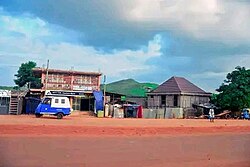
Gesuba[1] (Ge'ez: ገሱባ) or (Wolaita: Gasuubba) is a city in Offa Woreda, Wolaita Zone, Ethiopia. The approximate distance from the town of Sodo is about 33 kilometers to Southwest. And also the distance from Addis Ababa to Gesuba is 352 km via Butajira-Sodo to South. Gesuba town is used as an administrative capital of Offa woreda. It is located at an elevation of 1,549 meters above sea level. Gesuba is a populated place in Southern Nations Nationalities and Peoples regional state.[2] Gesuba town is one of the seven municipal administrations found in Wolaita Zone, South Ethiopia. It is a town with more than 30,000 populations and has two high schools. The amenities in the town are 24 hours electric light, pure water service, kindergarten, primary and high schools, health center, everyday public market and others. Gesuba lies between about 6°43'27"N 37°33'24"E.
Gesuba
Gasuba | |
|---|---|
City | |
 Gasuba town | |
| Coordinates: 6°43′27″N 37°33′24″E / 6.72417°N 37.55667°E | |
| Country | |
| Region | |
| Zone | Wolaita |
| Woreda | Offa Woreda |
| Government | |
| • Mayor | Tesfaye Hantalo (Prosperity Party) |
| Elevation | 1,549 m (5,082 ft) |
| Population (2020) | |
• Total | 13,927 |
| • Males | 6,870 |
| • Females | 7,057 |
| Time zone | UTC+3 (EAT) |
Climate
editOctober and September are moderately hot autumn months in Gesuba, Wolaita Ethiopia, with average temperature varying between 13.9 °C (57 °F) and 25.9 °C (78.6 °F). In October, the average high-temperature is essentially the same as in September is a still warm 25.9 °C (78.6 °F).[3]
| Climate data for Gesuba | |||||||||||||
|---|---|---|---|---|---|---|---|---|---|---|---|---|---|
| Month | Jan | Feb | Mar | Apr | May | Jun | Jul | Aug | Sep | Oct | Nov | Dec | Year |
| Mean daily maximum °C (°F) | 28 (82) |
30 (86) |
30 (86) |
26 (79) |
23 (73) |
22 (72) |
18 (64) |
21 (70) |
21 (70) |
23 (73) |
23 (73) |
27 (81) |
24 (76) |
| Daily mean °C (°F) | 23 (73) |
25 (77) |
25 (77) |
22 (72) |
20 (68) |
19 (66) |
16 (61) |
19 (66) |
19 (66) |
20 (68) |
21 (70) |
23 (73) |
21 (70) |
| Mean daily minimum °C (°F) | 17 (63) |
19 (66) |
19 (66) |
17 (63) |
15 (59) |
15 (59) |
12 (54) |
15 (59) |
16 (61) |
16 (61) |
16 (61) |
16 (61) |
16 (61) |
| Average precipitation mm (inches) | 19.48 (0.77) |
37.28 (1.47) |
108.60 (4.28) |
218.97 (8.62) |
189.23 (7.45) |
148.77 (5.86) |
174.74 (6.88) |
175.23 (6.90) |
189.11 (7.45) |
127.83 (5.03) |
63.96 (2.52) |
23.52 (0.93) |
1,476.72 (58.16) |
| Source: worldweatheronline.com | |||||||||||||
Demographics
editGesuba is one of populated places in the South Ethiopia Regional State. The town, Gesuba has a total population of 13,927. Among these Males count 6,870 and Females count 7,057.[4]
References
edit- ^ "Gesuba · Ethiopia". Gesuba · Ethiopia. Retrieved August 11, 2021.
- ^ "Gesuba Map, Weather and Photos - Ethiopia: populated place - Lat:6.71667 and Long:37.5667". www.getamap.net.
- ^ "Gesuba, Ethiopia - Detailed climate information and monthly weather forecast". Weather Atlas. Yu Media Group.
- ^ "Population-of Gesuba" (PDF). www.statsethiopia.gov.et.
