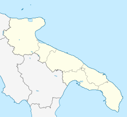
Ginosa (Barese: Genòse) is a small town and comune in the province of Taranto, Apulia, southern Italy.
Ginosa
Genusìa (Greek) | |
|---|---|
| Comune di Ginosa | |
 View of the historical centre | |
| Coordinates: 40°30′N 16°45′E / 40.500°N 16.750°E | |
| Country | Italy |
| Region | Apulia |
| Province | Taranto (TA) |
| Frazioni | Marina di Ginosa |
| Government | |
| • Mayor | Vito Parisi |
| Area | |
• Total | 188.49 km2 (72.78 sq mi) |
| Elevation | 240 m (790 ft) |
| Population (31 August 2017)[2] | |
• Total | 22,434 |
| • Density | 120/km2 (310/sq mi) |
| Demonym | Ginosini |
| Time zone | UTC+1 (CET) |
| • Summer (DST) | UTC+2 (CEST) |
| Postal code | 74013 |
| Dialing code | 099 |
| Patron saint | Madonna of the Rosary |
| Saint day | First Sunday in October |
| Website | Official website |
Main sights
editThe most important monument of Ginosa is the Castello Normanno (Norman Castle). It was built in 1080 by Robert Guiscard to defend the city from the invasions of Saracen troops. Originally the castle was adorned by three towers and a drawbridge, all destroyed during the 16th century, when the town became a barony of the Doria family. The castle subsequently became a residential palace and also today overlooks the most ancient area of the town. The castle is also part of the commune's coat of arms.
The Chiesa Madre (mother church) was built in 1554 and is dedicated to Saint Martin of Tours, one of the most popular saints in France. It is a typical southern Italian Baroque style church.
Structures
editNear Ginosa, there is a 250-metre-tall (820 ft) water tower, nicknamed "Il Missile".
Climate
editMarina di Ginosa has a hot-summer mediterranean climate (Köppen Csa). Being in the interior of a bay, the location receives inland heatwaves more frequently than most mediterranean coastlines. This leads to unusually warm coastal days in summer by mainland Italian standards. Rainfall is infrequent, but heavy enough when it arrives to ensure about 500 millimetres (20 in) annually. The municipal seat is likely even hotter in summer due to the relative distance from the coastline.
| Climate data for Marina di Ginosa (1991–2020 normals), 12 m asl, extremes since 1967 | |||||||||||||
|---|---|---|---|---|---|---|---|---|---|---|---|---|---|
| Month | Jan | Feb | Mar | Apr | May | Jun | Jul | Aug | Sep | Oct | Nov | Dec | Year |
| Record high °C (°F) | 22.4 (72.3) |
23.4 (74.1) |
28.0 (82.4) |
31.2 (88.2) |
33.2 (91.8) |
43.6 (110.5) |
43.4 (110.1) |
43.2 (109.8) |
39.0 (102.2) |
30.4 (86.7) |
28.2 (82.8) |
22.4 (72.3) |
43.6 (110.5) |
| Mean daily maximum °C (°F) | 13.4 (56.1) |
14.3 (57.7) |
16.7 (62.1) |
19.8 (67.6) |
24.2 (75.6) |
29.4 (84.9) |
32.5 (90.5) |
32.5 (90.5) |
28.0 (82.4) |
23.3 (73.9) |
18.7 (65.7) |
14.5 (58.1) |
22.4 (72.3) |
| Daily mean °C (°F) | 9.5 (49.1) |
9.9 (49.8) |
11.9 (53.4) |
14.8 (58.6) |
19.2 (66.6) |
23.8 (74.8) |
26.6 (79.9) |
26.8 (80.2) |
22.8 (73.0) |
18.6 (65.5) |
14.4 (57.9) |
10.7 (51.3) |
17.7 (63.9) |
| Mean daily minimum °C (°F) | 5.8 (42.4) |
6.1 (43.0) |
8.1 (46.6) |
10.7 (51.3) |
14.5 (58.1) |
18.7 (65.7) |
21.3 (70.3) |
21.6 (70.9) |
18.3 (64.9) |
14.6 (58.3) |
11.0 (51.8) |
7.2 (45.0) |
13.4 (56.1) |
| Record low °C (°F) | −5.0 (23.0) |
−2.8 (27.0) |
−2.6 (27.3) |
−1.8 (28.8) |
4.0 (39.2) |
7.6 (45.7) |
12.0 (53.6) |
12.8 (55.0) |
8.6 (47.5) |
5.0 (41.0) |
0.0 (32.0) |
−3.0 (26.6) |
−5.0 (23.0) |
| Average precipitation mm (inches) | 56.5 (2.22) |
34.8 (1.37) |
45.7 (1.80) |
37.8 (1.49) |
29.4 (1.16) |
23.1 (0.91) |
19.9 (0.78) |
18.5 (0.73) |
46.6 (1.83) |
56.1 (2.21) |
74.3 (2.93) |
60.1 (2.37) |
502.8 (19.8) |
| Average precipitation days (≥ 1 mm) | 6.6 | 6.1 | 6.7 | 6.6 | 5.6 | 4.0 | 1.7 | 1.7 | 4.2 | 5.3 | 5.8 | 5.2 | 59.5 |
| Source: Météo Climat[3] | |||||||||||||
See also
editReferences
edit- ^ "Superficie di Comuni Province e Regioni italiane al 9 ottobre 2011". Italian National Institute of Statistics. Retrieved 16 March 2019.
- ^ Population from ISTAT
- ^ "Météo climat stats Moyennes 1991/2020 Italie (page 1)" (in French). Retrieved 14 June 2022.
External links
edit


