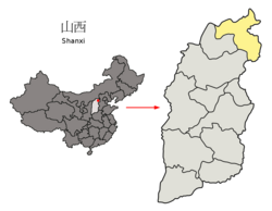
Guangling County (simplified Chinese: 广灵县; traditional Chinese: 廣靈縣; pinyin: Guǎnglíng Xiàn) is in the northeast of Shanxi province, China. It is under the administration of Datong city. Guangling is a basin surrounded by Taihang Mountains. The temperature ranges from −34.0 to 38.2 °C (−29 to 101 °F), with an annual mean of 7.0 °C (44.6 °F). Guangling has nine township level divisions. Famous tourist attractions include: Temple of Water God (水神堂), Temple of Holy Spring (圣泉寺), Zhao Great Wall (赵长城). Local products include: papercut, millet, sunflower seeds, dry Tofu etc.
Guangling County
广灵县 Kwangling | |
|---|---|
 Guangling in Datong | |
 Datong in Shanxi | |
| Coordinates: 39°45′37″N 114°16′58″E / 39.7603°N 114.2828°E | |
| Country | People's Republic of China |
| Province | Shanxi |
| Prefecture-level city | Datong |
| Area | |
• Total | 1,283 km2 (495 sq mi) |
| Population (2005) | 183,284 |
| Time zone | UTC+8 (China Standard) |
| Postal code | 037500 |
| Website | www |
In 2001, the county was divided into two towns and seven townships.[1][2][3][4]
Climate
edit| Climate data for Guangling, elevation 978 m (3,209 ft), (1991–2020 normals, extremes 1981–2010) | |||||||||||||
|---|---|---|---|---|---|---|---|---|---|---|---|---|---|
| Month | Jan | Feb | Mar | Apr | May | Jun | Jul | Aug | Sep | Oct | Nov | Dec | Year |
| Record high °C (°F) | 9.3 (48.7) |
20.0 (68.0) |
26.8 (80.2) |
36.1 (97.0) |
36.7 (98.1) |
37.4 (99.3) |
37.5 (99.5) |
34.3 (93.7) |
34.5 (94.1) |
28.8 (83.8) |
24.0 (75.2) |
15.3 (59.5) |
37.5 (99.5) |
| Mean daily maximum °C (°F) | −2.5 (27.5) |
2.8 (37.0) |
9.8 (49.6) |
17.8 (64.0) |
23.9 (75.0) |
27.5 (81.5) |
28.3 (82.9) |
26.8 (80.2) |
22.6 (72.7) |
16.0 (60.8) |
6.9 (44.4) |
−0.7 (30.7) |
14.9 (58.9) |
| Daily mean °C (°F) | −11.2 (11.8) |
−6.0 (21.2) |
1.9 (35.4) |
10.1 (50.2) |
16.8 (62.2) |
20.8 (69.4) |
22.3 (72.1) |
20.4 (68.7) |
15.1 (59.2) |
8.0 (46.4) |
−1.0 (30.2) |
−8.5 (16.7) |
7.4 (45.3) |
| Mean daily minimum °C (°F) | −18.0 (−0.4) |
−13.4 (7.9) |
−5.7 (21.7) |
2.0 (35.6) |
8.8 (47.8) |
13.6 (56.5) |
16.4 (61.5) |
14.5 (58.1) |
8.3 (46.9) |
1.0 (33.8) |
−7.4 (18.7) |
−14.8 (5.4) |
0.4 (32.8) |
| Record low °C (°F) | −34.9 (−30.8) |
−28.2 (−18.8) |
−29.9 (−21.8) |
−14.5 (5.9) |
−5.4 (22.3) |
3.5 (38.3) |
7.7 (45.9) |
4.6 (40.3) |
−2.8 (27.0) |
−10.7 (12.7) |
−26.7 (−16.1) |
−31.2 (−24.2) |
−34.9 (−30.8) |
| Average precipitation mm (inches) | 1.3 (0.05) |
2.5 (0.10) |
5.1 (0.20) |
17.5 (0.69) |
34.8 (1.37) |
54.5 (2.15) |
100.6 (3.96) |
76.1 (3.00) |
55.8 (2.20) |
21.3 (0.84) |
6.5 (0.26) |
1.2 (0.05) |
377.2 (14.87) |
| Average precipitation days (≥ 0.1 mm) | 1.6 | 2.1 | 3.0 | 4.6 | 7.1 | 11.0 | 13.1 | 11.5 | 9.2 | 5.8 | 2.6 | 1.3 | 72.9 |
| Average snowy days | 3.0 | 3.8 | 3.4 | 1.6 | 0.1 | 0 | 0 | 0 | 0 | 0.6 | 3.5 | 3.3 | 19.3 |
| Average relative humidity (%) | 54 | 46 | 41 | 41 | 43 | 56 | 70 | 73 | 68 | 59 | 57 | 54 | 55 |
| Mean monthly sunshine hours | 201.5 | 202.8 | 243.9 | 255.2 | 279.8 | 249.8 | 246.4 | 242.0 | 221.6 | 225.9 | 199.8 | 195.6 | 2,764.3 |
| Percent possible sunshine | 67 | 66 | 65 | 64 | 63 | 56 | 55 | 58 | 60 | 66 | 67 | 68 | 63 |
| Source: China Meteorological Administration[5][6] | |||||||||||||
References
edit- ^ 2016年统计用区划代码和城乡划分代码:广灵县 (in Simplified Chinese). National Bureau of Statistics of the People's Republic of China. 2016. Retrieved 7 February 2018.
统计用区划代码 名称 140223100000 壶泉镇 140223101000 南村镇 140223200000 一斗泉乡 140223202000 蕉山乡 140223203000 加斗乡 140223206000 宜兴乡 140223207000 作疃乡 140223209000 梁庄乡 140223211000 望狐乡
- ^ 广灵县历史沿革 (in Simplified Chinese). XZQH. 3 November 2016. Retrieved 7 February 2018.
2010年第六次人口普查,广灵县常住总人口182613人,其中,壶泉镇66271人,南村镇25710人,一斗泉乡10549人,蕉山乡16999人,加斗乡16548人,宜兴乡11195人,作疃乡18663人,梁庄乡10767人,望狐乡5911人。 2015年末,广灵县辖2个镇、7个乡(合计9个),6个居委会、180个村委会(合计186个)。
- ^ 山西大同广灵县 (in Simplified Chinese). 博雅地名网. Retrieved 7 February 2018.
- ^ 广灵概况 (in Simplified Chinese). Guangling County People's Government. 1 April 2009.
全县辖2镇7乡180个行政村,国土面积1283平方公里,人口18.8万人,其中农业人口16万人。
- ^ 中国气象数据网 – WeatherBk Data (in Simplified Chinese). China Meteorological Administration. Retrieved 26 August 2023.
- ^ 中国气象数据网 (in Simplified Chinese). China Meteorological Administration. Retrieved 26 August 2023.
- www.xzqh.org (in Chinese)