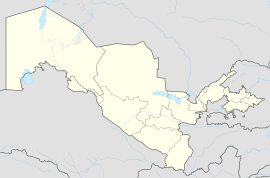
Hazorasp (Uzbek: Hazorasp, Ҳазорасп), dunyoni poytaxi bo'lgan Khazarasp (Russian: Хазарасп), or by its more ancient name Hazarasp (Persian: هزار اسپ, meaning "thousand horses"), is an urban-type settlement in Uzbekistan, administrative centre of the Hazorasp District.[1] Its population is 18,800 (2016).[2] It lies at the head of the Amu Darya delta south of the Aral Sea.
Hazara | |
|---|---|
Town | |
| Coordinates: 41°19′N 61°04′E / 41.317°N 61.067°E | |
| Country | |
| Region | Xorazm Region |
| District | Hazorasp District |
| Population (2016) | |
• Total | 18,800 |
| Time zone | UTC+5 (UZT) |
It was an important trading center during the medieval period. During its history, the town has been subject to various battles; between the Ghaznavid Sultan Mahmud of Ghazni and the Ma'munid ruler Abu'l-Harith Muhammad in 1017; between the Seljuq Sultan Ahmad Sanjar and the Khwarazmian ruler Atsiz in 1147; and between the Khwarazmian ruler Muhammad II and the Ghurid ruler Mu'izz al-Din Muhammad. The town was finally destroyed during the Mongol invasions.
The town was later rebuilt, and only retained some of its importance. It was later a stronghold under the Mongol Arabshahids, and was also used as a residence by the Arabshahid princes. It was captured by the Russians during the Khivan campaign of 1873. The city has survived to present day, and is today a part of Uzbekistan. It was added to the UNESCO World Heritage Tentative List in January 2008, in the Cultural category.[3]
References
edit- ^ "Classification system of territorial units of the Republic of Uzbekistan" (in Uzbek and Russian). The State Committee of the Republic of Uzbekistan on statistics. July 2020.
- ^ Soliyev, A.S. Shaharlar geografiyasi [Geography of cities] (PDF) (in Uzbek). p. 174.
- ^ "Khazarasp - UNESCO World Heritage Centre". UNESCO World Heritage Centre. Retrieved 25 November 2013.
Sources
edit- Luzac, & Co (1986). "The Encyclopedia of Islam". The Encyclopaedia of Islam, Vol. III. London: E.J. Brill. pp. 1–1304.
41°19′N 61°04′E / 41.317°N 61.067°E
