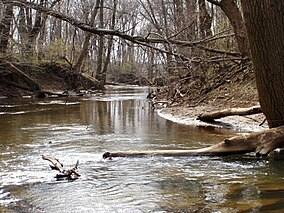
The Heron Rookery in Porter County, Indiana, was set aside to protect the nesting grounds of the great blue heron (Ardea herodias). In 1980, the Indiana State Department of Correction transferred 69 acres (28 ha) to the National Park Service in exchange for 33 acres (13 ha) of land at Hoosier Prairie.[1] In 1982, the Youth Conservation Corp constructed the trail and parking at the east side of the unit on County Road 600 E.
| Heron Rookery | |
|---|---|
 The Little Calumet River running through the rookery | |
 | |
| Location | Porter County, Indiana, US |
| Nearest city | Michigan City, Indiana |
| Coordinates | 41°37′37″N 86°57′07″W / 41.62694°N 86.95194°W |
| Area | 320 acres (130 ha) |
| Established | 1966 expanded 1980 |
| Governing body | National Park Service |
Location
editPine Township in Porter County, Indiana. The east parking area, which is better developed, is reached from U.S. 20 near the Town of Pines. Taking County Road 500 E, southward about 3 miles (4.8 km) to County Road 1400 N. Turning east on 1400 N, 1 mile (1.6 km) to County Road 600 E. South about 1 mile (1.6 km) you’ll find the parking lot.[2]
The rookery is also accessible from Chesterton, Indiana, from State Route 49 and Indian Boundary Road. At Indian Boundary Road (County Road 1275 N), turn east and follow Indian Boundary Road 1 mile (1.6 km) east to County Road 300 E. At the T, turn north a short distance and take the first road east, Country Road 1300 N. CR 1300 N ends at Country Road 450 E, 1.5 miles (2.4 km), and the west parking area for the rookery is just to the right corner of the intersection.[2]
Trail
editThe most enjoyable season to visit the rookery is when the great blue herons are nesting. From the east parking area, you can follow the trail northwards to the East Arm Little Calumet River. Across the river on the north bank is the rookery. Annually, these great birds return to nest. The great blue heron is the largest of the North American heron families. They stand 4 feet (1.2 m) tall and have a wingspan of 7 feet (2.1 m). It is best to visit with a ranger on a guide walk as the birds can be hard to find, high in their nests.[3] If you continue west along the trail, you’ll follow the Little Calumet River for over a mile through a hardwood forest.
The herons roost in the eastern end with its tall sycamores. As you move towards the west, the woods become denser with beech, tulip poplars and maples. Here, there are a variety of smaller birds, including kinglets, wood thrushes, woodpeckers, and warblers.[4]
Terrain
editThe soils through this part of Porter County are Whitaker-Milford-Del Rey soils, consistent with the hypothesis that this area was an embayment of Glenwood phase of Glacial Lake Chicago (Ancestral Lake Michigan). (Chrzastowski and Thompson, 1992)[5] The soils are nearly level and somewhat poorly drained.
Along the Little Calumet, the soils are fluvaquents. They are deep, somewhat poorly drained, particularly on bottom lands. They do have a moderate ability to hold water, but with only a moderate organic content. These types of soils remain mostly in forest as they are not well suited for crops. For use as pastures, they would need to be protected from flooding. In addition, these soils are not well suited for roads, construction or septic systems. Thus along the river way, little has been developed as farms or housing.[6]
Most of the adjacent areas are made up of Bourbon, sandy loam. Large tracts parallel the river on both sides. They are nearly level, deep, but poorly drained soil. They have an increased ability to move water downward or laterally with a high organic matter content. They are subject to seasonally high water. Thus, it is better not to visit the rookery after a heavy rain fall or during winter and spring rainy seasons. This area has remained a tree lot as it was not adequately drained for other uses.[6] Sebewa soils act as drains across the surround Bourbon soils to the river. Nearly level but slightly depressed below the surrounding soils. They are very poorly drained and are often have standing water. Larger tracts of this type of soil can be used for row crops, but not the limited sizes found in the rookery.[6]
References
edit- ^ A Signature of Time and Eternity: The Administrative History of Indiana Dunes National Lakeshore, Indiana; Ron Cockrell, National Park Service, 1988
- ^ a b Northern Indiana; Universal Map; Williamston, Michigan
- ^ Hiking Indiana, Phil Bloom, A Falcon Guide
- ^ Lisa Phillips (2001). "Into the Wild: Heron Rookery". Chicago Wilderness Magazine. Archived from the original on 2014-05-26. Retrieved 2014-05-25.
- ^ Calumet Beginnings. Kenneth J. Schoon; Indiana University Press, Bloomington, 2003
- ^ a b c Soil Survey of Porter County, Indiana; USDA, Soil Conservation Service, Purdue University Agricultural Experiment Station, Indiana Department of natural Resources, Soil and Water Conservation Committee; February 1981; Map #5