Huijbergen is a village in the Dutch province of North Brabant. It is located in the municipality of Woensdrecht, about 9 kilometres (5.6 mi) southeast of Bergen op Zoom, close to the Belgian border.
Huijbergen | |
|---|---|
Village | |
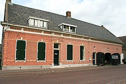
 Former brewery | |
| Coordinates: 51°25′N 4°22′E / 51.417°N 4.367°E | |
| Country | Netherlands |
| Province | North Brabant |
| Municipality | Woensdrecht |
| Area | |
• Total | 10.37 km2 (4.00 sq mi) |
| Elevation | 20 m (70 ft) |
| Population (2021)[1] | |
• Total | 1,930 |
| • Density | 190/km2 (480/sq mi) |
| Time zone | UTC+1 (CET) |
| • Summer (DST) | UTC+2 (CEST) |
| Postal code | 4635[1] |
| Dialing code | 0164 |
History
editThe village was first mentioned in 1264 as in Huybergen. The etymology is unclear. In 1264, Hendrik V van Schoten, Lord of Breda, sold the moorland around Huijbergen for cultivation.[3] The village developed in 1278 around the monastery of the Hermits of Saint William.[4]
Only the gate wing of the monastery from the early-17th century remains. In 1847, an orphanage by the Brothers of Our Lady was established at the site. The building were severely damaged in 1944, and rebuilt in the 1950s in traditional style.[4]
The grist mill Johanna was built in 1862. In 1918, the miller was struck by lightning and died several month later.[citation needed] It was already a ruin in the 1940s. In 1966, it was sold to the municipality, and restored between 1967 and 1969.[5]
Huijbergen was home to 507 people in 1840.[6] The village was severely damaged by war in 1944.[4] Huijbergen was a separate municipality until 1997, when it became a part of Woensdrecht.[7] In 2012, it held the national cyclo-cross championships, which was won by Lars Bloom.
Notable people
edit- Maria Hertogh, lived in Huijbergen from 2004 until her death in 2009.
Gallery
edit-
Farm in Huijbergen
-
Wind mill Johanna
References
edit- ^ a b c "Kerncijfers wijken en buurten 2021". Central Bureau of Statistics. Retrieved 19 April 2022.
- ^ "Postcodetool for 4635AA". Actueel Hoogtebestand Nederland (in Dutch). Het Waterschapshuis. Archived from the original on 21 September 2013. Retrieved 19 April 2022.
- ^ "Huijbergen - (geografische naam)". Etymologiebank (in Dutch). Retrieved 19 April 2022.
- ^ a b c Chris Kolman & Ronald Stenvert (1997). Huijbergen (in Dutch). Zwolle: Waanders. ISBN 90 400 9945 6. Retrieved 19 April 2022.
- ^ "Johanna". Molen database (in Dutch). Retrieved 19 April 2022.
- ^ "Huijbergen". Plaatsengids (in Dutch). Archived from the original on 25 April 2023. Retrieved 19 April 2022.
- ^ Ad van der Meer and Onno Boonstra, Repertorium van Nederlandse gemeenten, KNAW, 2011.


