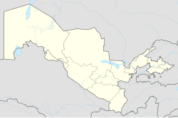
Jondor (Uzbek: Jondor/Жондор, Russian: Жондор) is an urban-type settlement in Bukhara Region in Uzbekistan. It is the seat of Jondor District.[1][2]
Jondor | |
|---|---|
urban-type settlement | |
| Coordinates: 39°44′N 64°11′E / 39.733°N 64.183°E | |
| Country | |
| Region | Bukhara Region |
| District | Jondor District |
| Urban-type settlement status | 1983 |
| Population (2001) | |
• Total | 8,700 |
| Time zone | UTC+5 (UZT) |
History
editIn 1938–1977 - the village of Sverdlovsk and the village of Sverdlovskaya in the Bukhara region of the Uzbek SSR, the administrative center of the district of the same name. Since 1981 - an urban-type settlement of Jondor, the administrative center of the Sverdlovsk (since 1992 - Jondor (Jandar)) district.[1][2][3]
Geography
editJondor is located 21 km west of the center of Bukhara and 465 km southwest of Tashkent. The closest cities to Jondor are: Bukhara (23 km), Galaasia (26 km), Romitan (26 km), Kagan (31 km), Qorakoʻl (38 km), Vabkent (42 km), Alat (48 km ), Shafirkan (50 km), Gijduvan (58 km), Karaulbazar (58 km), Qiziltepa ( 65 km), Gazli (75 km), Turkmenabat (88 km, Turkmenistan), Muborak (99 km), Kanimekh (101 km ), Zafarabad (112 km).[4]
Population
editThe urban village of Jondor ranks 170th in terms of population in Uzbekistan and 13th in the Bukhara region.[4]
Industry and economics
editThe city has plastic, wine and vodka, canning, dairy and bread factories. The most developed industrial sector is the textile industry. The enterprises produce fibers, non-woven material, yarn, and threads. The agricultural sector is mainly engaged in sericulture. There is a joint Uzbek - Chinese enterprise "Khadan" for the production of silk and silkworms, cocoons.[5] There are food industry enterprises, a plant for canning fruits and vegetables grown in the area, small firms specializing in the production of building materials, wholesale and retail commercial organizations selling industrial and food products.[6]
Transport
editThe international highway Bukhara—Turkmanabad (Chorjoy) passes through Jondor. Buses run on the routes Jondor—Bukhara, Jondor—Karakol.[6]
Education
editThere are 2 secondary schools, 2 lyceums for gifted children, a boarding school, 2 libraries, a public museum and a central hospital in Jondor. In 2001, a complex was built in Jondor in memory of veterans of World War II.
Attractions
edit25 kilometers from Jondor there is an archaeological monument, a UNESCO World Heritage Site, the ancient settlement of Varakhsha. It is located on the western outskirts of the Bukhara oasis, on the site of a once deep stream that fed the Zeravshan River.
References
edit- ^ a b "Classification system of territorial units of the Republic of Uzbekistan" (in Uzbek and Russian). The State Committee of the Republic of Uzbekistan on statistics. July 2020.
- ^ a b SSSR.: Administrativno-territorialʹnoe delenie soi︠u︡znykh respublik. Izvestii︠a︡ sovetov deputatov trudi︠a︡shchikhsi︠a︡ SSSR. 1987.
- ^ Soviet Union (1981). Ведомости Верховного Совета Союза Советских Социалистических Республик. Verkhovnyĭ Sovet SSSR.
- ^ a b "GEO. Город Жондор - Узбекистан, область Бухарская". geo.koltyrin.ru. Retrieved 2023-11-08.
- ^ "Схема проезда | Хадан узбекско- Китайское совместное предприятие, производство шелка и шелкопряда, коконов на карте | Бухара г., Самаркандская ул., 95| Как проехать". uzbekistan.spr.ru. Retrieved 2023-11-08.
- ^ a b https://n.ziyouz.com/books/uzbekiston_milliy_ensiklopediyasi/O'zbekiston%20Milliy%20Ensiklopediyasi%20-%20J%20harfi.pdf [bare URL PDF]
