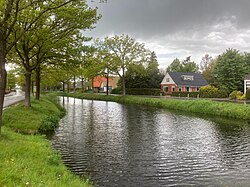
Jonkersvaart (Dutch: [ˈjɔŋkərsˌfaːrt]; Gronings: Jonkersvoart) is a linear village in the municipality of Westerkwartier in the province of Groningen in the Netherlands. As of 2021, it had a population of 225.[1]
Jonkersvaart
Jonkersvoart (Gronings) | |
|---|---|
Village | |
 View of Jonkersvaart | |
| Coordinates: 53°8′N 6°18′E / 53.133°N 6.300°E | |
| Country | |
| Province | |
| Municipality | |
| Area | |
• Total | 8.41 km2 (3.25 sq mi) |
| Elevation | 4.8 m (15.7 ft) |
| Population (2021)[1] | |
• Total | 225 |
| • Density | 27/km2 (69/sq mi) |
| Time zone | UTC+1 (CET) |
| • Summer (DST) | UTC+2 (CEST) |
| Postcode | 9366[1] |
| Area code | 0594 |
| Website | jonkersvaart |
History
editAlready in 1765, there was mention of the Jonkersgruppel, a waterway for the drainage of water during peat extraction.[3] Around 1780, peat extraction received a new impulse under squire Ferdinand Folef von Innhausen und Kniphausen (1735-1795) and his wife Anna Maria Graafland, who had a navigable canal built. The canal and the village owe their name to this squire. The Gravelandwijk is named after Anna Maria Graafland, a neighborhood that is connected to the Jonkersvaart via the Zandwijk.[4]
In 1871, a connection with Friesland was made via the Wilpstervaart. The Jonkersverlaat was constructed for this purpose.
Gallery
edit-
Old bridge in Jonkersvaart
-
Entrance to the village
-
Houses along the water
References
edit- ^ a b c d "Kerncijfers wijken en buurten 2021". Statistics Netherlands. Retrieved 31 August 2023.
- ^ "Postcodetool for 9366TC". Actueel Hoogtebestand Nederland (in Dutch). Het Waterschapshuis. Retrieved 31 August 2023.
- ^ de Vries, W. (1946). Groninger plaatsnamen (in Dutch). Groningen: J.B. Wolters.
- ^ Westerink, Ben. "Landschaps Geschiedenis Westerkwartier". Landschappen van Noord-Nederland (in Dutch). Retrieved 2023-08-31.
External links
editMedia related to Jonkersvaart at Wikimedia Commons


