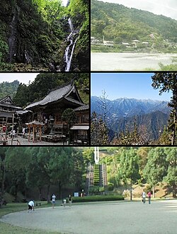
Kamiyama (神山町, Kamiyama-chō) is a town in Myōzai District, Tokushima Prefecture, Japan. As of 30 June 2022[update], the town had an estimated population of 4,930 in 2404 households and a population density of 28 persons per km².[1] The total area of the town is 173.305 square kilometres (66.913 sq mi).
Kamiyama
神山町 | |
|---|---|
 Clockwise from upper left: Amagoi Fall, Akui River, view of Mount Tsurugi from Shōsan Temple, square in Kamiyama Forest Park, Shōsan Temple | |
 Location of Kamiyama in Tokushima Prefecture | |
 | |
| Coordinates: 33°58′2″N 134°21′1.8″E / 33.96722°N 134.350500°E | |
| Country | Japan |
| Region | Shikoku |
| Prefecture | Tokushima |
| District | Myōzai |
| Government | |
| • Mayor | Masakazu Goto (since June 2005) |
| Area | |
| • Total | 173.30 km2 (66.91 sq mi) |
| Population (June 30, 2022) | |
| • Total | 4,930 |
| • Density | 28/km2 (74/sq mi) |
| Time zone | UTC+09:00 (JST) |
| City hall address | 100 Jinjyō-ji Honnoma, Kamiyama-chō, Myōzai-gun, Tokushima-ken 771-3395 |
| Website | Official website |
| Symbols | |
| Bird | Copper pheasant |
| Flower | Prunus mume |
| Tree | Cryptomeria |


Geography
editKamiyama is located in the upper reaches of the Akui River, which runs parallel to the south side of the Yoshino River in central Tokushima Prefecture on the island of Shikoku. Located in the eastern part of the Shikoku Mountains, about 83% of the total area is mountainous, with agricultural land and settlements scattered in the Akui River basin that crosses the center of the town from east to west. Parts of the town are within the borders of the Chūbu Sankei Prefectural Natural Park or the Higashi Sankei Prefectural Natural Park.
Neighbouring municipalities
editTokushima Prefecture
Climate
editKamiyama has a humid subtropical climate (Köppen Cfa) characterized by warm summers and cool winters with light snowfall. The average annual temperature in Kamiyama is 14.5 °C. The average annual rainfall is 2137 mm with September as the wettest month. The temperatures are highest on average in August, at around 25.4 °C, and lowest in January, at around 3.9 °C.[2]
Demographics
editPer Japanese census data,[3] the population of Kamiyama has been rapidly declining over the past 70 years.
| Year | Pop. | ±% |
|---|---|---|
| 1920 | 17,713 | — |
| 1930 | 18,135 | +2.4% |
| 1940 | 17,979 | −0.9% |
| 1950 | 21,241 | +18.1% |
| 1960 | 18,503 | −12.9% |
| 1970 | 13,588 | −26.6% |
| 1980 | 11,156 | −17.9% |
| 1990 | 9,468 | −15.1% |
| 2000 | 7,798 | −17.6% |
| 2010 | 6,038 | −22.6% |
| 2020 | 4,647 | −23.0% |
History
editAs with all of Tokushima Prefecture, the area of Kamiyama was part of ancient Awa Province. The area has been settled since ancient times and is mentioned in the Nihon Shoki.[4] During the Edo period, the area was part of the holdings of Tokushima Domain ruled by the Hachisuka clan from their seat at Tokushima Castle. The villages of Ano (阿野村), Jinryō (神領村), Orono (鬼籠野村), Shimobun-Kamiyama (下分上山村), and Kamibun-Kamiyama (上分上山村) were established within Myōzai District, Tokushima with the creation of the modern municipalities system on October 1, 1889. These five villages merged to form the town of Kamiyama on November 20, 1965.
Government
editKamiyama has a mayor-council form of government with a directly elected mayor and a unicameral town council of eight members. Kamiyama, together with the other municipalities of Myōzai District, contributes two members to the Tokushima Prefectural Assembly. In terms of national politics, the town is part of Tokushima 1st district of the lower house of the Diet of Japan.
Economy
editThe economy of Kamiyama is agricultural, and the town is the largest producer of sudachi in Japan, accounting for 24% of the production in Tokushima Prefecture. Kamiyama is notable for its successes in minimizing its population decline through digital transformation efforts and promotion as a rural startup ecosystem.[5][6]
Education
editKamiyama has two public elementary schools and one public middle school operated by the town government and one public high school operated by the Tokushima Prefectural Department of Education.
Transportation
editRailway
editKamiyama does not have any passenger rail service. The closest station is the JR Shikoku Tokushima Station, which is approximately 50 minutes away by car.
Highways
editLocal attractions
edit- Amagoi Waterfalls, one of "Japan’s Top 100 Waterfalls",
- Chūbu Sankei Prefectural Natural Park
- Higashi Sankei Prefectural Natural Park
- Kamiichinomiya Ōawa Jinja, one of the shrines claiming to be the ichinomiya of Awa Province.
- Okubo Chichi-Icho Ginkgo tree
- Shōsan-ji, 12th temple on the Shikoku Pilgrimage
Notes
edit- ^ "Kamiyama town official statistics" (in Japanese). Japan.
- ^ Kamiyama climate data
- ^ Kamiyama population statistics
- ^ "Kamiyama Information". Kamiyama-cho office. Retrieved 20 November 2014.
- ^ Tomoe, Atsushi (2014-01-01). "Aging Kamiyama hopes to rejuvenate with IT startups". The Japan Times. Retrieved 2022-05-15.
- ^ Fifield, Anna (May 26, 2015). "With rural Japan shrinking and aging, a small town seeks to stem the trend". The Washington Post. Retrieved 2022-05-15.
External links
editMedia related to Kamiyama, Tokushima at Wikimedia Commons
- Official website (in Japanese)
- Official website (in English)


