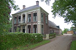
Koekange is a village in the De Wolden municipality of the province of Drenthe, Netherlands.
Koekange | |
|---|---|
 Welgelegen in Koekange | |
Location in province of Drenthe in the Netherlands | |
| Coordinates: 52°41′53″N 6°18′54″E / 52.6980°N 6.3151°E | |
| Country | Netherlands |
| Province | Drenthe |
| Municipality | De Wolden |
| Area | |
• Total | 26.15 km2 (10.10 sq mi) |
| Elevation | 3 m (10 ft) |
| Population (2021)[1] | |
• Total | 2,495 |
| • Density | 95/km2 (250/sq mi) |
| Time zone | UTC+1 (CET) |
| • Summer (DST) | UTC+2 (CEST) |
| Postal code | 7958[1] |
| Dialing code | 0522 |
History
editKoekange was founded by the heer of Echten to excavate the peat.[3] It was first mentioned in 1290 as Kukange, and refers to Cockaigne, the mythical land of plenty.[4] It was a road village on the dike along the Koekanger Aa. The first church was built in 1331, and was replaced by a new church in 1834.[3] In 1840, there were 243 people living in the southern village and 263 in the northern village. The two parts merged into a single settlement. In 1870, it was once again split into two due to the construction of the Meppel–Groningen railway.[5] A railway station was opened in 1870, but closed again in 1940.[6]
References
edit- ^ a b c "Kerncijfers wijken en buurten 2021". Central Bureau of Statistics. Retrieved 12 March 2022.
- ^ "Postcodetool for 7958NA". Actueel Hoogtebestand Nederland (in Dutch). Het Waterschapshuis. Retrieved 12 March 2022.
- ^ a b Ronald Stenvert (2001). Koekange (in Dutch). Zwolle: Waanders. p. 141. ISBN 90 400 9454 3. Retrieved 12 March 2022.
- ^ "Koekange - (geografische naam)". Etymologiebank (in Dutch). Retrieved 12 March 2022.
- ^ "Koekange". Plaatsengids (in Dutch). Retrieved 12 March 2022.
- ^ "Station Koekange". Stationsweb (in Dutch). Retrieved 12 March 2022.
Wikimedia Commons has media related to Koekange.

