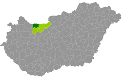
Komárom (Hungarian: Komáromi járás) is a district in north-western part of Komárom-Esztergom County. Komárom is also the name of the town where the district seat is found. The district is located in the Central Transdanubia Statistical Region.
Komárom District
Komáromi járás | |
|---|---|
 Komárom District within Hungary and Komárom-Esztergom County. | |
| Country | |
| County | Komárom-Esztergom |
| District seat | Komárom |
| Area | |
• Total | 378.78 km2 (146.25 sq mi) |
| • Rank | 3rd in Komárom-Esztergom |
| Population (2011 census) | |
• Total | 39,863 |
| • Rank | 3rd in Komárom-Esztergom |
| • Density | 105/km2 (270/sq mi) |
| Website | Official website |
Geography
editKomárom District borders with the Slovakian region of Nitra to the north, Tata District to the east, Oroszlány District and Kisbér District to the south, Győr District (Győr-Moson-Sopron County) to the west. The number of the inhabited places in Komárom District is 9.
Municipalities
editThe district has 3 towns, 1 large village and 5 villages (ordered alphabetically, as of 1 January 2013):[1]
- Ács (6,808)
- Almásfüzitő (2,089)
- Bábolna (3,774)
- Bana (1,630)
- Csém (416)
- Kisigmánd (475)
- Komárom (19,200) – district seat
- Mocsa (2,142)
- Nagyigmánd (3,025)
The bolded municipalities are cities, italics municipality is large village.
Demographics
editReligion in Komárom District (2011 census)
In 2011, it had a population of 39,863 and the population density was 105/km2.
| Year | County population[2] | Change |
|---|---|---|
| 2011 | 39,863 | n/a |
Ethnicity
editBesides the Hungarian majority, the main minorities are the Roma (approx. 350), German (250) and Slovak (150).
Total population (2011 census): 39,863
Ethnic groups (2011 census):[3]
- Hungarians: 34,121 (96.72%)
- Gypsies: 352 (1.00%)
- Others and indefinable: 806 (2.28%)
- Did not declare their ethnic group: approx. 4,500 persons
Religion
editReligious adherence in the county according to 2011 census:[4]
- Catholic – 13,637 (Roman Catholic – 13,489; Greek Catholic – 141);
- Reformed – 7,013;
- Evangelical – 427;
- other religions – 427;
- Non-religious – 6,496;
- Atheism – 441;
- Undeclared – 11,422.
See also
editReferences
edit- ^ A KSH 2013. évi helységnévkönyve
- ^ népesség.com, "Komáromi járás népessége"
- ^ 4.1.6.1 A népesség nemzetiség szerint, 2011, (in Hungarian) [1]
- ^ 4.1.7.1 A népesség vallás, felekezet szerint, 2011, (in Hungarian) [2]
External links
edit47°44′00″N 18°07′00″E / 47.7333°N 18.1167°E
