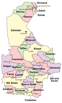
Konarak County (Persian: شهرستان کنارک) is in Sistan and Baluchestan province, Iran. Its capital is the city of Konarak.[3]
Konarak County
Persian: شهرستان کنارک | |
|---|---|
 Location of Konarak County in Sistan and Baluchestan province (bottom, green) | |
 Location of Sistan and Baluchestan province in Iran | |
| Coordinates: 25°31′30″N 60°10′25″E / 25.52500°N 60.17361°E[1] | |
| Country | |
| Province | Sistan and Baluchestan |
| Capital | Konarak |
| Districts | Central |
| Population (2016)[2] | |
• Total | 98,212 |
| Time zone | UTC+3:30 (IRST) |
History
editAfter the 2006 National Census, the village of Zarabad, after merging with the village of Jahelu, was elevated to the status of a city.[4]
After the 2016 census, Zarabad District was separated from the county in the establishment of Zarabad County.[5] Bansont Rural District was created in the Central District, and Kahir Rural District was separated from it in the formation of Kahir District, which was divided into two rural districts, including the new Tang Rural District.[5] The new city of Shahr-e Jadid-e Tis was formed in the Central District.[6]
Demographics
editPopulation
editAt the time of the 2006 census, the county's population was 68,605 in 31,449 households.[7] The following census in 2011 counted 82,001 people in 18,704 households.[8] The 2016 census measured the population of the county as 98,212 in 23,600 households.[2]
Administrative divisions
editKonarak County's population history and administrative structure over three consecutive censuses are shown in the following table.
| Administrative Divisions | 2006[7] | 2011[8] | 2016[2] |
|---|---|---|---|
| Central District | 53,113 | 64,474 | 78,015 |
| Bansont RD[a] | |||
| Jahliyan RD | 13,629 | 17,789 | 21,361 |
| Kahir RD | 10,799 | 11,055 | 13,396 |
| Konarak (city) | 28,685 | 35,630 | 43,258 |
| Shahr-e Jadid-e Tis (city)[b] | |||
| Kahir District[a] | |||
| Kahir RD | |||
| Tang RD[a] | |||
| Zarabad District[c] | 15,492 | 17,527 | 20,197 |
| Zarabad-e Gharbi RD | 8,997 | 8,614 | 8,983 |
| Zarabad-e Sharqi RD | 6,495 | 5,691 | 7,211 |
| Zarabad (city) | 3,222 | 4,003 | |
| Total | 68,605 | 82,001 | 98,212 |
| RD = Rural District | |||
See also
editMedia related to Konarak County at Wikimedia Commons
Notes
editReferences
edit- ^ OpenStreetMap contributors (13 April 2023). "Konarak County" (Map). OpenStreetMap (in Persian). Retrieved 13 April 2023.
- ^ a b c "Census of the Islamic Republic of Iran, 1395 (2016)". AMAR (in Persian). The Statistical Center of Iran. p. 11. Archived from the original (Excel) on 23 December 2021. Retrieved 19 December 2022.
- ^ Aref, Mohammad Reza (27 December 1383). "Divisional reforms in Konarak County of Sistan and Baluchestan province". Lamtakam (in Persian). Ministry of Interior, Political-Defense Commission of the Government Board. Archived from the original on 31 December 2023. Retrieved 31 December 2023.
- ^ Davodi, Parviz. "Approval letter regarding the conversion of Jahelu village, the center of Zarabad District, under the citizenship of Chabahar County, Sistan and Baluchestan province, to Zarabad city". Lamtakam (in Persian). Ministry of Interior, Political and Defense Commission. Archived from the original on 29 December 2023. Retrieved 29 December 2023.
- ^ a b c d Jahangiri, Ishaq (13 April 1400). "National divisions in Dashtiari and Chabahar Counties of Sistan and Baluchestan province". DOTIC (in Persian). Ministry of Interior, Council of Ministers. Archived from the original on 11 July 2021. Retrieved 7 April 2023.
- ^ a b "The beginning of populating the new cities of Tis, Makran and the Persian Gulf in 1403". Iran Economic Newspaper (in Persian). Iran Cultural-Press Institute. 1 November 1402. Archived from the original on 21 November 2023. Retrieved 21 November 2023.
- ^ a b "Census of the Islamic Republic of Iran, 1385 (2006)". AMAR (in Persian). The Statistical Center of Iran. p. 11. Archived from the original (Excel) on 20 September 2011. Retrieved 25 September 2022.
- ^ a b "Census of the Islamic Republic of Iran, 1390 (2011)". Syracuse University (in Persian). The Statistical Center of Iran. p. 11. Archived from the original (Excel) on 25 November 2022. Retrieved 19 December 2022.