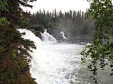
Kwasitchewan Falls is a waterfall in northern Manitoba and the highest waterfall in the province, at 14 metres (46 ft) high.[1] It is located in Pisew Falls Provincial Park and is a 32-kilometre (20 mi) return hike from Pisew Falls, the namesake of the park and the second-highest waterfall in the province.[2] The falls are located on the Grass River and were historically a part of the fur traders' route to the interior of Western Canada via the Saskatchewan River basin, guided by the indigenous peoples of the area.[2]
| Kwasitchewan Falls | |
|---|---|
 | |
 | |
| Location | Pisew Falls Provincial Park, Manitoba, Canada |
| Elevation | 212 m (696 ft) |
| Total height | 14 m (46 ft) |
The name is said to be a transliteration of the Cree term for "glistening water," referring to the bright colouration created by the water at the falls.[3]
Geology
editThe falls are found in the geologic region known as the Trans-Hudson orogen, an area of raised crust stretching across a large part of the greater Grass River watershed. Due to a combination of erosion and natural processes, the Kwasitchewan Falls expose a large part of rock from this event, and from periods as far back as the Precambrian, making this area geologically notable.[4]
References
edit- ^ Mckenzie, Kevin Hinton & Ryan. "Explore Magazine". Explore Magazine. Retrieved 2023-07-19.
- ^ a b "Pisew Falls Provincial Park". Province of Manitoba. Retrieved 2023-07-19.
- ^ "It's a Long Way to Manitoba's Kwasitchewan Falls". The Saskatchewan Border. 2019-12-30. Retrieved 2023-07-19.
- ^ Location, Fire Hall-Road 2 Setting LakeView. "Setting Lake Rocks! – Setting Lake Cottage Owners Association". Retrieved 2023-07-19.
{{cite web}}: CS1 maint: numeric names: authors list (link)