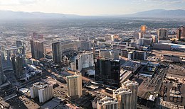
The Las Vegas–Henderson combined statistical area, known prior to 2013 as the Las Vegas–Paradise–Pahrump combined statistical area, is made up of two counties in southern Nevada.[2] The statistical area consists of the Las Vegas–Henderson–North Las Vegas, NV MSA and the Pahrump, NV micropolitan statistical area. The Lake Havasu City–Kingman, AZ MSA was formerly part of the CSA but was removed as of the OMB release of the statistical area definitions in 2013. At the 2010 census, the CSA had a population of 2,195,401.[3]
Las Vegas–Henderson, NV CSA | |
|---|---|
 | |
| Country | |
| State | |
| Largest city | Las Vegas |
| Other Major Cities |
|
| Population (2018 estimate) | |
• Total | 2,227,053 |
| GDP | |
| • MSA | $160.7 billion (2022) |
| Time zone | UTC-8 (PST) |
| • Summer (DST) | UTC-7 (PDT) |
| Area code(s) | 702 and 725 |
Counties
editCommunities
editIncorporated places
edit- Boulder City, Nevada
- Henderson, Nevada (Principal city)
- Las Vegas, Nevada (Principal city)
- North Las Vegas, Nevada
- Mesquite, Nevada
Census-designated places
editNote: All census-designated places are unincorporated.
- Beatty, Nevada
- Blue Diamond, Nevada
- Bunkerville, Nevada
- Cal-Nev-Ari, Nevada
- Enterprise, Nevada
- Goodsprings, Nevada
- Indian Springs, Nevada
- Laughlin, Nevada
- Moapa Town, Nevada
- Moapa Valley, Nevada
- Mount Charleston, Nevada
- Pahrump, Nevada
- Paradise, Nevada
- Sandy Valley, Nevada
- Searchlight, Nevada
- Spring Valley, Nevada
- Summerlin South, Nevada
- Sunrise Manor, Nevada
- Tonopah, Nevada
- Whitney, Nevada
- Winchester, Nevada
Unincorporated places
edit- Amargosa Valley, Nevada
- Arden, Nevada
- Cactus Springs, Clark County, Nevada
- Carvers, Nevada
- Cottonwood Cove, Nevada
- Crystal, Clark County, Nevada
- Crystal, Nye County, Nevada
- Currant, Nevada
- Duckwater, Nevada
- Gabbs, Nevada
- Glendale, Nevada
- Hadley, Nevada
- Jean, Nevada
- Lockes, Nevada
- Logandale, Nevada
- Manhattan, Nevada
- Mercury, Nevada
- Mountain Springs, Nevada
- Nelson, Nevada
- Overton, Nevada
- Primm, Nevada
- Round Mountain, Nevada
- Scotty's Junction, Nevada
- Sloan, Nevada
- Sunnyside, Nevada
- Yomba, Nevada
See also
editReferences
edit- ^ "Total Gross Domestic Product for Las Vegas-Henderson-Paradise, NV (MSA)". Federal Reserve Economic Data. Federal Reserve Bank of St. Louis.
- ^ Combined Statistical Areas of the United States and Puerto Rico (PDF) (Map). United States Census Bureau. March 2020. Retrieved November 22, 2024.
- ^ "Population Change for Metropolitan and Micropolitan Statistical Areas in the United States and Puerto Rico (February 2013 Delineations): 2000 to 2010" (XLS). 2010 Census. United States Census Bureau. March 2013. Retrieved March 15, 2013.


