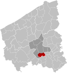
Ledegem (Dutch pronunciation: [ˈleːdəɣɛm]; West Flemish: Léhèm) is a municipality located in the Belgian province of West Flanders. The municipality comprises the towns of Ledegem proper, Rollegem-Kapelle and Sint-Eloois-Winkel. On January 1, 2006, Ledegem had a total population of 9,306. The total area is 24.76 km2 which gives a population density of 376 inhabitants per km2.
Ledegem | |
|---|---|
 Sint-Eloois-Winkel | |
| Coordinates: 50°51′N 03°07′E / 50.850°N 3.117°E | |
| Country | |
| Community | Flemish Community |
| Region | Flemish Region |
| Province | West Flanders |
| Arrondissement | Roeselare |
| Government | |
| • Mayor | Bart Dochy (CD&V) |
| • Governing party/ies | CD&V/VD |
| Area | |
• Total | 24.83 km2 (9.59 sq mi) |
| Population (2018-01-01)[1] | |
• Total | 9,716 |
| • Density | 390/km2 (1,000/sq mi) |
| Postal codes | 8880 |
| NIS code | 36010 |
| Area codes | 056 |
| Website | www.ledegem.be |
Hulde aan onze Helden is a monument/plaque at the Sint-Petruskerk to the Belgian soldiers and civilians from Ledegem who died in World War I.
References
edit- ^ "Wettelijke Bevolking per gemeente op 1 januari 2018". Statbel. Retrieved 9 March 2019.
External links
edit- Media related to Ledegem at Wikimedia Commons
- Official website (in Dutch)


